Erkner
From Wikipedia, the free encyclopedia
| Erkner | ||
|---|---|---|
| ||
 Erkner | ||
Location of Erkner within Oder-Spree district  | ||
| Coordinates: 52°25′N 13°45′E / 52.417°N 13.750°ECoordinates: 52°25′N 13°45′E / 52.417°N 13.750°E | ||
| Country | Germany | |
| State | Brandenburg | |
| District | Oder-Spree | |
| Government | ||
| • Mayor | Jochen Kirsch (SPD) | |
| Area | ||
| • Total | 16.60 km2 (6.41 sq mi) | |
| Elevation | 40 m (130 ft) | |
| Population (2012-12-31)[1] | ||
| • Total | 11,438 | |
| • Density | 690/km2 (1,800/sq mi) | |
| Time zone | CET/CEST (UTC+1/+2) | |
| Postal codes | 15537 | |
| Dialling codes | 03362 | |
| Vehicle registration | LOS | |
| Website | www.erkner.de | |
Erkner (first called ""Arckenow"") is a town in the Oder-Spree District of Brandenburg, Germany.
Geography
It is situated on the river Spree, 23 km west of Fürstenwalde, and directly on the border to Berlin-Rahnsdorf.
Demography
-

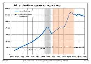
Development of Population since 1875 within the Actual Boundaries (Blue Line: Population; Dotted Line: Comparison to Population Development of Brandenburg state; Grey Background: Time of Nazi rule; Red Background: Time of Communist rule)
-

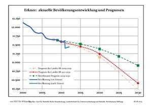
Recent Population Development (Blue Line) and Forecasts
Photogallery
-

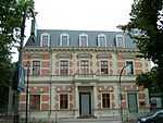
City Hall
-

Railway Station
See also
References
- ↑ "Bevölkerung im Land Brandenburg nach amtsfreien Gemeinden, Ämtern und Gemeinden 31. Dezember 2012 (XLS-Datei; 83 KB) (Einwohnerzahlen auf Grundlage des Zensus 2011)". Amt für Statistik Berlin-Brandenburg (in German). 31 December 2012.
External links
![]() Media related to Erkner at Wikimedia Commons
Media related to Erkner at Wikimedia Commons
This article is issued from Wikipedia. The text is available under the Creative Commons Attribution/Share Alike; additional terms may apply for the media files.
