Erkerode
From Wikipedia, the free encyclopedia
| Erkerode | ||
|---|---|---|
| ||
 Erkerode | ||
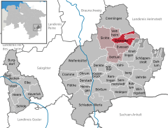
Location of Erkerode within Wolfenbüttel district 
 | ||
| Coordinates: 52°13′N 10°42′E / 52.217°N 10.700°ECoordinates: 52°13′N 10°42′E / 52.217°N 10.700°E | ||
| Country | Germany | |
| State | Lower Saxony | |
| District | Wolfenbüttel | |
| Municipal assoc. | Sickte | |
| Government | ||
| • Mayor | Dr. Claus Harmsen (SPD) | |
| Area | ||
| • Total | 13.34 km2 (5.15 sq mi) | |
| Elevation | 60-180 m (−530 ft) | |
| Population (2012-12-31)[1] | ||
| • Total | 968 | |
| • Density | 73/km2 (190/sq mi) | |
| Time zone | CET/CEST (UTC+1/+2) | |
| Postal codes | 38173 | |
| Dialling codes | 05305 | |
| Vehicle registration | WF | |
Erkerode is a small village and a community in the District of Wolfenbüttel, in the south-east of Lower Saxony, Germany. It is nearly 16 kilometres (9.9 mi) south-east of Braunschweig. The Elm, a range of forested hills, is close by.
The town of Erkerode was first mentioned in historic documents in 1175 (Erikeroth). The village belonged to the noble family of Veltheim since the 12th century. It was part of the court of Destedt. There are still many medieval farm houses of various types to be seen in the village today.
See also
 Media related to Erkerode at Wikimedia Commons

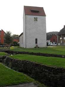
Protestant church in Erkerode
References
This article is issued from Wikipedia. The text is available under the Creative Commons Attribution/Share Alike; additional terms may apply for the media files.
