Erebuni district
Coordinates: 40°08′23″N 44°31′40″E / 40.13972°N 44.52778°E
| Erebuni Էրեբունի | |
|---|---|
 | |
 | |
| Coordinates: 40°08′23″N 44°31′40″E / 40.13972°N 44.52778°E | |
| Country | Armenia |
| Marz (Province) | Yerevan |
| Government | |
| • Mayor of District | Armen Harutyunyan |
| Area | |
| • Total | 48.41 km2 (18.69 sq mi) |
| Population (2011 est.) | |
| • Total | 122,500 |
| Time zone | (UTC+4) |
Erebuni (Armenian: Էրեբունի) is a district of Yerevan, the capital of Armenia. It is situated southeast of the city centre where Erebuni Fortress is located. The name of Yerevan itself is derived from Erebuni. At the census in 2001, it had a population of over 126,200. It is bordered by Shengavit District from the west, Kentron, Nork-Marash and Nor Nork districts from the north, Kotayk Province from the east, Nubarashen district and Kotayk Province from the south. Its main thoroughfare is Erebuni street. The district is commonly divided into eight smaller neighborhoods: Erebuni block, Nor Aresh, Saritagh, Vardashen, Mushavan, Verin Jrashen, Kayaran and Nor Butaniya.
The district has an area of 48.41 km², out of which 29.09 km² are occupied by buildings. It is served by the Sasuntsi Davit metro station.
The Yerevan Railway Station is located in the Sasuntsi Davit square of Erebuni district.
The formation
On 20 July 1939, according to a decision passed by the Communist Party of Armenia, a new district was formed in Yerevan city named the "Moldavian Regional Soviet". Later, on 25 September 1957 the regional soviet was renamed after Lenin. Once again, on 13 November 1961 the name of the district was changed and renamed after Ordzhonikidze.[1]
The name of Erebuni was given to the region only on 8 August 1991 by the decision of the Supreme Assembly of Armenia. In 1996, Yerevan was divided into 12 local communities and since 1997, Erebuni holds the status of "district" (Armenian: համայնք hamaynk).
History
The first settlers of the area were the survivors (around 60 families) of the Armenian genocide who escaped from the district of Butaniya in Western Armenia and founded the neighborhood of Nor Butaniya in 1925.
Nor Aresh is named after the old Armenian district of Aresh. The first inhabitants of Nor Aresh arrived from Nukhi, Azerbaijan. Following the Armenian repatriatsion process in 1946, Nor Aresh and Vardashen neighborhoods were resettled by Armenian migrants from Syria, Lebanon, Greece, France, Bulgaria and Egypt.[2]
Mushavan, originally a village near Yerevan, was absorbed by the city since 1965 to become part of Erebuni district.
Streets, squares and parks
.JPG)
- Erebuni street
- Sasuntsi Davit street
- Azatamartikneri (Liberators') Avenue
- Artsakh Avenue
- Ivan Ayvazovsky street
- Rostov-on-Don street
- Moses of Chorene street
- David Bek street
- Arin Berd street
- Sasuntsi Davit square
- Lyon Park
Historic and cultural structures

- Erebuni Fortress of 782 BC at Arin Berd.
- Erebuni museum near the Erebuni Fortress.
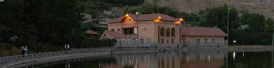
- The Araratian water reservoir known as Vardavar lake in Lyon park. The park is also home to the first Genocide memorial erected in Yerevan.
- The Military cemetery and Arin Berd pantheon.
- The statue of David of Sasun near the railway station.
Industry
Erebuni district is home to many industrial plants:
- Armenian Molybdenum Production
- Armenian Travertine Mining Company (ATMC)
- Clear Metal Factory
Other sites
- Erebuni stadium with 550 seats
- The Yerevan Hunting Club
- Central Jail of Yerevan
- Аutobazaar, the open-air car market
Gallery
- Erebuni district
-
.JPG)
The statue of Argishti I
-
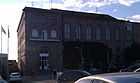
The administrative building of Erebuni district
-

General view of the district with the main Erebuni street

References
External links
- Erebuni district municipality official website
- '32FA886619CD3774E0440003BA962ED3'&Diacritics=DC Erebuni district at GEOnet Names Server
- Report of the results of the 2001 Armenian Census, National Statistical Service of the Republic of Armenia
| |||||||||