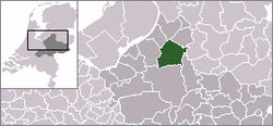
Epe
From Wikipedia, the free encyclopedia
| Epe | |||
|---|---|---|---|
| Municipality | |||
| |||
 | |||
| Coordinates: 52°21′N 05°59′E / 52.350°N 5.983°ECoordinates: 52°21′N 05°59′E / 52.350°N 5.983°E | |||
| Country | Netherlands | ||
| Province | Gelderland | ||
| Area(2006) | |||
| • Total | 157.25 km2 (60.71 sq mi) | ||
| • Land | 156.21 km2 (60.31 sq mi) | ||
| • Water | 1.04 km2 (0.40 sq mi) | ||
| Population (1 January 2007) | |||
| • Total | 32,999 | ||
| • Density | 211/km2 (550/sq mi) | ||
| Source: CBS, Statline. | |||
| Time zone | CET (UTC+1) | ||
| • Summer (DST) | CEST (UTC+2) | ||
 Epe (Dutch pronunciation: [ˈeːpə] (
![]() )) is a municipality and a town in the eastern Netherlands.
)) is a municipality and a town in the eastern Netherlands.
The town has 15,593 (01-01-2007) inhabitants, whilst the municipality as a whole has a population of 32,989. The town hall stands in Epe, which is situated about 16 km (9.9 mi) north of Apeldoorn and 21 km (13 mi) south of Zwolle.
Another important town within the municipality is Vaassen (12,739 inhabitants), halfway between Epe and Apeldoorn. It has an interesting castle called 'De Cannenburgh', which is open to visitors (guided tour compulsory). Epe, Vaassen and also the village of Oene each have a beautiful medieval church. Other population centres of interest are Emst, Gortel, Tongeren, Wissel and Zuuk.
International relations
Twin towns – Sister cities
Epe is twinned with:
Famous people from the municipality of Epe
- Marc Overmars (Emst, 1973), football player. Played for AFC Ajax, Arsenal F.C. and F.C. Barcelona.
- Teun Mulder (Zuuk, 1981), track cyclist.
- Esther Hart (Epe, 1970), singer.
- Helen Fermate (Halfweg, 1964), artist.
External links
 Media related to Epe, Gelderland at Wikimedia Commons
- Official Website
 |
Elburg | Oldebroek, Heerde |  | |
| Nunspeet | |
Olst-Wijhe (OV) | ||
| ||||
| | ||||
| Apeldoorn | Voorst |
| ||||||||||||||
This article is issued from Wikipedia. The text is available under the Creative Commons Attribution/Share Alike; additional terms may apply for the media files.


