Ensay, Outer Hebrides
| Ensay | |
|---|---|
| Location | |
 Ensay | |
| OS grid reference | NF977862 |
| Names | |
| Gaelic name | Easaigh |
| Meaning of name | Old Norse: Ewe Island |
| Area and summit | |
| Area | 186 ha (0.72 sq mi) |
| Area rank | 113[1] |
| Highest elevation | 49 m (161 ft) |
| Population | |
| Population | 0 |
| Groupings | |
| Island group | Outer Hebrides |
| Local Authority | Na h-Eileanan Siar |
| References | [2][3][4] |
Ensay (Gaelic Easaigh) is a currently unpopulated island in the Outer Hebrides of Scotland. The island lies in the Sound of Harris between the islands of Harris and Berneray. The name originates from the Old Norse for Ewe Island.[4] It is nothing to do with the Gaelic for Jesus - "Iosa" - as sometimes stated.
Although the island has had no permanent population since the 1930s, it is still used for summer grazing. The small chapel of Christ Church is maintained and services are held biannually.[5] The island is classified by the National Records of Scotland as an inhabited island that "had no usual residents at the time of either the 2001 or 2011 censuses."[6]
The island shows signs of Stone Age habitation, with a prominent standing stone. Ensay House (Taigh Easaigh) was built in the Edwardian period.[7] This was the home of the Stewart family (of which Ed Stewart is a descendant); they used to own the island.[citation needed]
The town of Ensay in Victoria, Australia was named after this island by one of the early settlers, a Scotsman named Archibald Macleod.[citation needed]
Gallery
-
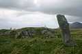
Standing Stone
-

Taigh Easaigh
References
- ↑ Area and population ranks: there are c. 300 islands >20ha in extent and 93 permanently inhabited islands were listed in the 2011 census.
- ↑ Haswell-Smith, Hamish (2004). The Scottish Islands. Edinburgh: Canongate. ISBN 978-1-84195-454-7.
- ↑ Ordnance Survey. Get-a-map (Map). 1:25,000. Leisure. http://www.ordnancesurvey.co.uk/oswebsite/getamap/. Retrieved 21 August 2013.
- ↑ 4.0 4.1 Mac an Tàilleir, Iain (2003) Ainmean-àite/Placenames. (pdf) Pàrlamaid na h-Alba. Retrieved 26 August 2012.
- ↑ "Harris - Christ Church". Diocese of Argyll & The Isles. Retrieved 2007-12-08.
- ↑ National Records of Scotland (15 August 2013) (pdf) Statistical Bulletin: 2011 Census: First Results on Population and Household Estimates for Scotland - Release 1C (Part Two). "Appendix 2: Population and households on Scotland’s inhabited islands". Retrieved 17 August 2013.
- ↑ "Ensay". Gazetteer for Scotland. Retrieved 2007-12-08.
| Wikimedia Commons has media related to Ensay, Scotland. |
Coordinates: 57°46′N 7°5′W / 57.767°N 7.083°W
| |||||
| ||||||||||||||||||||||||||||||||||||||||||||||||||||||||||||||||||||||||||||||||||||||||||||||||||||||||||||||||||||||||||||||||||||||||||||||||||||||||||||||||
