Elos
| Elos Έλος | |
|---|---|
| Location | |
 Elos | |
| Coordinates | 36°50′N 22°42′E / 36.833°N 22.700°ECoordinates: 36°50′N 22°42′E / 36.833°N 22.700°E |
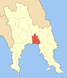
Location within the regional unit  | |
| Government | |
| Country: | Greece |
| Administrative region: | Peloponnese |
| Regional unit: | Laconia |
| Municipality: | Evrotas |
| Population statistics (as of 2001)[1] | |
| Municipal unit | |
| - Population: | 6,452 |
| Other | |
| Time zone: | EET/EEST (UTC+2/3) |
| Elevation (center): | 15 m (49 ft) |
| Postal code: | 230 55 |
| Telephone: | 27350 |
| Auto: | ΑΚ |
Elos (Greek: Έλος) is a village and a former municipality in Laconia, Peloponnese, Greece. Since the 2011 local government reform it is part of the municipality Evrotas, of which it is a municipal unit.[2] It was called Durali until 1912. The population of the village is 920 people as of 2001. The municipal unit has 6,452 inhabitants. The seat of the municipality was in Vlachioti. The inhabitants work as farmers producing oranges and olive oil. The municipal unit has a coastline on the Laconian Gulf. The Evrotas River is west of Elos. The name dates back to ancient times. It is located W of Monemvasia, E of Gytheio and SE of Sparta.
Mythology
Pausanias (geographer) mentions a seaside city near Sparta called Helos, whose inhabitants were enslaved and became the helots.[3] Helos was founded by Helios, the younger son of Perseus.[3] The city was reduced by siege by the Dorians, and their inhabitants became the first slaves of the Lacedemonian state.[3]
Historical population
| Year | Municipal district | Municipality |
|---|---|---|
| 1981 | 756 | - |
| 1991 | 824 | 5,992 |
| 2001 | 920 | 6,452 |
References
- ↑ De Facto Population of Greece Population and Housing Census of March 18th, 2001 (PDF 793 KB). National Statistical Service of Greece. 2003.
- ↑ Kallikratis law Greece Ministry of Interior (Greek)
- ↑ 3.0 3.1 3.2 Description of Greece, 3.20.6, by Pausanias (geographer)
See also
| |||||||||||||||||