Ellingwood Point
From Wikipedia, the free encyclopedia
| Ellingwood Point | |
|---|---|
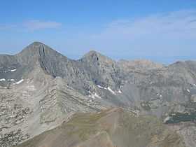
 View of Blanca Peak (left) and Ellingwood Point (center) from summit of Mount Lindsey | |
| Elevation | 14,048 ft (4,282 m) NAVD 88[1] |
| Prominence | 322 ft (98 m)[1] |
| Parent peak | Blanca Peak |
| Listing | Colorado Fourteener |
| Location | |
 Ellingwood Point | |
| Location | Alamosa / Huerfano counties, Colorado, U.S. |
| Range | Sangre de Cristo Range |
| Coordinates | 37°34′57″N 105°29′33″W / 37.58250°N 105.49250°WCoordinates: 37°34′57″N 105°29′33″W / 37.58250°N 105.49250°W[2] |
| Topo map | USGS Blanca Peak |
| Climbing | |
| Easiest route | Class 2 scramble |
Ellingwood Point, or Ellingwood Peak, is a fourteener in the U.S. state of Colorado. It is located at the southern end of the Sangre de Cristo Range, approximately 1/2 mile (1 km) northwest of Blanca Peak. It lies on the border between Alamosa County and Huerfano County. It is named for Albert Russell Ellingwood, an early pioneer of climbing in the Western United States and in Colorado in particular.
Ellingwood Point only barely qualifies as an independent peak under the 300-foot (91 m) topographic prominence cutoff which is standard in Colorado. It is also quite close to its parent peak, Blanca Peak. Hence its inclusion in fourteener lists has been somewhat controversial. However most authorities do consider it a true fourteener.[3]
See also
References
- ↑ 1.0 1.1 "Ellingwood Point, Colorado". Peakbagger.com. Retrieved 2013-05-30.
- ↑ "Ellingwood Point". Geographic Names Information System, U.S. Geological Survey. Retrieved 2011-02-22.
- ↑ Louis W. Dawson II (1996). Dawson's Guide to Colorado's Fourteeners, Volume 2. Blue Clover Press. ISBN 0-9628867-2-6.
External links
- "Blanca Peak and Ellingwood Point". 14ers.com. Retrieved 2011-05-15.
- "Ellingwood Point". SummitPost.org. http://www.summitpost.org/page/150451. Retrieved 2011-05-15.

A view of Ellingwood Point and Blanca Peak from just above the Blue Lakes
This article is issued from Wikipedia. The text is available under the Creative Commons Attribution/Share Alike; additional terms may apply for the media files.