Elbingerode, Lower Saxony
From Wikipedia, the free encyclopedia
For Elbingerode in Saxony-Anhalt, see Elbingerode.
| Elbingerode | ||
|---|---|---|
| ||
 Elbingerode | ||
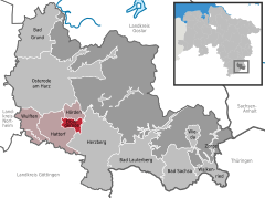
Location of Elbingerode within Osterode am Harz district 
 | ||
| Coordinates: 51°39′33″N 10°16′45″E / 51.65917°N 10.27917°ECoordinates: 51°39′33″N 10°16′45″E / 51.65917°N 10.27917°E | ||
| Country | Germany | |
| State | Lower Saxony | |
| District | Osterode am Harz | |
| Municipal assoc. | Hattorf am Harz | |
| Area | ||
| • Total | 5.66 km2 (2.19 sq mi) | |
| Elevation | 200 m (700 ft) | |
| Population (2012-12-31)[1] | ||
| • Total | 486 | |
| • Density | 86/km2 (220/sq mi) | |
| Time zone | CET/CEST (UTC+1/+2) | |
| Postal codes | 37412 | |
| Dialling codes | 05521 | |
| Vehicle registration | OHA | |
| Website | www.elbingero.de | |
Elbingerode is a municipality in the district of Osterode, in Lower Saxony, Germany.
Geography
Geographycal location
Elbingerode is in the Harz National Park near the Sieber river. Elbingerode belongs to the municipality of Hattorf am Harz. The village is in the immediate proximity of Bundesstraße 27, which results from Göttingen to Blankenburg.
| |||||||
References
This article is issued from Wikipedia. The text is available under the Creative Commons Attribution/Share Alike; additional terms may apply for the media files.
