Elbingen
| Elbingen | ||
|---|---|---|
| ||
 Elbingen | ||
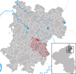
Location of Elbingen within Westerwaldkreis district  | ||
| Coordinates: 50°31′45″N 7°54′40″E / 50.52917°N 7.91111°ECoordinates: 50°31′45″N 7°54′40″E / 50.52917°N 7.91111°E | ||
| Country | Germany | |
| State | Rhineland-Palatinate | |
| District | Westerwaldkreis | |
| Municipal assoc. | Wallmerod | |
| Government | ||
| • Mayor | Horst Hartenfels (CDU) | |
| Area | ||
| • Total | 2.30 km2 (0.89 sq mi) | |
| Elevation | 380 m (1,250 ft) | |
| Population (2012-12-31)[1] | ||
| • Total | 293 | |
| • Density | 130/km2 (330/sq mi) | |
| Time zone | CET/CEST (UTC+1/+2) | |
| Postal codes | 56459 | |
| Dialling codes | 06435 | |
| Vehicle registration | WW | |
| Website | www.elbingen.de | |
Elbingen is an Ortsgemeinde – a community belonging to a Verbandsgemeinde – in the Westerwaldkreis in Rhineland-Palatinate, Germany.
Geography
Location
The community lies in the Westerwald between Montabaur and Westerburg. Surrounded by a well cared-for and charming landscape, Elbingen lies in the middle of a wooded area with many hiking and cycling trails. The community belongs to the Verbandsgemeinde of Wallmerod, a kind of collective municipality.
History
In 1383, Elbingen had its first documentary mention as Elmennyngen and once lay in the area of the Niederlahngau, the lordly domain of the Counts of Nassau. The name can be traced to the ancient name Alaman, leading to the conclusion that there was an earlier Germanic settlement here. Only later did the name Elbingen come to be associated with the Elb, the important Westerwald river that runs through the municipal area. In a document from 1383, Friedrich von Elmennyngen is named; however, no coat of arms from this middle-noble family has been handed down. Other noble families, such as von Hattert, von Reifenberg (arms red and silver) and von Dehrn had holdings here. The long era in which the House of Nassau held sway was interrupted in 1564 when the parish of Salz, and thereby Elbingen, passed to the Electorate of Trier. By 1806, however, Elbingen passed back to Nassau and belonged until 1866 to the Duchy of Nassau, and thereafter to the Prussian province of Hesse-Nassau. The civic arms bear a golden lion armed and langued gules (ie with red claws and tongue) on a blue field, which was the charge seen on the arms borne by the Counts of Nassau. This refers to the great span of time when the community was under Nassau’s sway.
Besides the village itself, an oilmill on the Kälberbach is mentioned in 1739, which by 1786 was somewhat inexplicably named Spießmühle (“Spear Mill”), but it still stands below the village now and is used as a dwelling. The Spießmühle is symbolically represented in the arms by the red half waterwheel in silver. Red and silver are the tinctures of the Electorate of Trier and thus they bear witness to Elbingen’s time in the “Trierschland”. The silver-blue wavy fesses stand for the Elbbach, the Kälberbach and the reservoir built in 1967, part of which covers Elbingen’s municipal area, making a great recreation area on the Elbingen shore.
Elbingen’s municipal area has always been characterized by agriculture, which for a long time was the inhabitants’ main source of earnings. The waterwheel is therefore also a symbol for agriculture, whose produce was processed at the mill.
Besides a small amount of basalt and brown coal mining, clay bricks were also fired in the 19th century. At the same time, Elbingers would fire their stoneware, such as jugs and so forth for household use. From this custom arose the name Elwinger Kriielcher, which Elbingers have kept to this day and bear with pride. This is symbolized by the silver jug in the Nassau lion’s paws.
The community was once united with Mähren as of 1969, and the amalgamation bore the name Elbingen-Mähren. It was, however, dissolved again in 1993.
Economy and infrastructure
The village, in which roughly 310 people live today, has retained its individual character in a cared-for and neighbourly atmosphere, underscored by a successful village renewal project with much greenery. Particularly worthy of note is the newly remodelled village square around the bakehouse and the old timber-frame middle-class house (Bürgerhaus) that is enjoyed by families for its “homely appearance”.
On the community limits bordering Hahn am See lies a private lake in the woods with a camping ground and trailer park.
References
- ↑ "Bevölkerung der Gemeinden am 31.12.2012". Statistisches Bundesamt (in German). 2013.
External links
- Elbingen (German)
- Elbingen in the collective municipality’s Web pages (German)
- Hierzuland television (German)
- map (German)
Images
-

Bürgerhaus
-

Dorfkrug ("Village Jug")
-

Elbingen
- This article incorporates information from the German Wikipedia.
