Eiterfeld
From Wikipedia, the free encyclopedia
| Eiterfeld | ||
|---|---|---|
| ||
 Eiterfeld | ||
Location of Eiterfeld within Fulda district 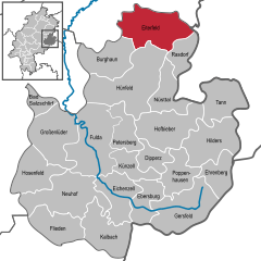
 | ||
| Coordinates: 50°46′N 09°48′E / 50.767°N 9.800°ECoordinates: 50°46′N 09°48′E / 50.767°N 9.800°E | ||
| Country | Germany | |
| State | Hesse | |
| Admin. region | Kassel | |
| District | Fulda | |
| Subdivisions | 17 districts | |
| Government | ||
| • Mayor | Hermann-Josef Scheich (Ind.) | |
| Area | ||
| • Total | 89.83 km2 (34.68 sq mi) | |
| Elevation | 349 m (1,145 ft) | |
| Population (2012-12-31)[1] | ||
| • Total | 7,176 | |
| • Density | 80/km2 (210/sq mi) | |
| Time zone | CET/CEST (UTC+1/+2) | |
| Postal codes | 36132 | |
| Dialling codes | 06672 | |
| Vehicle registration | FD | |
| Website | www.eiterfeld.de | |

Eiterfeld is a municipality in the district of Fulda, in Hesse, Germany. It is situated in the north of the district, 25 km north of Fulda.
See also
- Schloss Buchenau
- Burg Fürsteneck
References
- ↑ "Die Bevölkerung der hessischen Gemeinden". Hessisches Statistisches Landesamt (in German). July 2013.
External links
- Official site (German)
- Schloss Buchenau (German)
- Burg Fürsteneck (German)

Castle Burg Fürsteneck
| Wikimedia Commons has media related to Eiterfeld. |
| |||||||
This article is issued from Wikipedia. The text is available under the Creative Commons Attribution/Share Alike; additional terms may apply for the media files.