Edermünde
From Wikipedia, the free encyclopedia
| Edermünde | ||
|---|---|---|
| ||
 Edermünde | ||
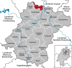
Location of Edermünde within Schwalm-Eder-Kreis district 
 | ||
| Coordinates: 51°12′N 09°25′E / 51.200°N 9.417°ECoordinates: 51°12′N 09°25′E / 51.200°N 9.417°E | ||
| Country | Germany | |
| State | Hesse | |
| Admin. region | Kassel | |
| District | Schwalm-Eder-Kreis | |
| Subdivisions | 4 Ortsteile | |
| Government | ||
| • Mayor | Karl-Heinz Färber (SPD) | |
| Area | ||
| • Total | 25.83 km2 (9.97 sq mi) | |
| Elevation | 197 m (646 ft) | |
| Population (2012-12-31)[1] | ||
| • Total | 7,300 | |
| • Density | 280/km2 (730/sq mi) | |
| Time zone | CET/CEST (UTC+1/+2) | |
| Postal codes | 34295 | |
| Dialling codes | 05665 / 05603 | |
| Vehicle registration | HR | |
| Website | www.edermuende.de | |
Edermünde (German: for mouth of the Eder) is a community in northern Hesse, Germany.
Geography
Location
Edermünde lies in the north of the Schwalm-Eder district not far southwest of Kassel. This is where the river Eder empties into the river Fulda. The constituent community of Besse is nestled in the Langenberge range that rises to the west.
Constituent communities
The community consists of the centres of Besse, Grifte, Haldorf and Holzhausen am Hahn.
Neighbouring communities
Edermünde is surrounded by four neighbouring communities:
- Baunatal in the north (borders directly)
- Guxhagen in the east (across the Fulda)
- Gudensberg in the south (borders directly)
- Niedenstein in the west (across the Langenberge)
Politics
Municipal partnerships
-
 Terenten (Terento), South Tyrol, Italy, since 1989.
Culture and sightseeing
Museums
- Heimatmuseum ("Homeland Museum") in Haldorf (in former herdsman's house)
- Dorfmuseum Holzhausen ("Holzhausen Village Museum") in the DGH (Holzhausen Culture and History Club)
Buildings
- "Fortress church" in Besse
Natural monuments
- River Hahn in Holzhausen
The basalt knoll offers an outstanding view of the surrounding area. The path up to the plateau was built anew by Holzhausen citizens in the years 1999 and 2000 and is in good hiking condition.
Sons and daughters of the community
- Eckebrecht von Grifte (mediaeval military man)
References
- ↑ "Die Bevölkerung der hessischen Gemeinden". Hessisches Statistisches Landesamt (in German). July 2013.
- This article incorporates information from the German Wikipedia.
External links
| |||||||
This article is issued from Wikipedia. The text is available under the Creative Commons Attribution/Share Alike; additional terms may apply for the media files.
