East Walker River
| East Walker River | |
| River | |
| Country | United States |
|---|---|
| States | California, Nevada |
| Source | Sierra Nevada |
| - location | California |
| - elevation | 6,570 ft (2,003 m) |
| - coordinates | 38°11′44″N 119°17′09″W / 38.19556°N 119.28583°W [1] |
| Mouth | Walker River |
| - location | Yerington, Nevada |
| - elevation | 4,442 ft (1,354 m) |
| - coordinates | 38°53′34″N 119°10′46″W / 38.89278°N 119.17944°W [1] |
| Length | 90 mi (145 km), south-north |
| Basin | 1,230 sq mi (3,186 km2) |
| Discharge | for near Mason, Nevada |
| - average | 150 cu ft/s (4 m3/s) |
| - max | 2,820 cu ft/s (80 m3/s) |
| - min | 2.3 cu ft/s (0 m3/s) |
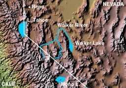 Walker River, showing the West Walker and East Walker rivers
| |
The East Walker River is a tributary of the Walker River, approximately 90 miles (140 km) long,[2] in eastern California and western Nevada in the United States. It drains part of the eastern side of the Sierra Nevada in the watershed of Walker Lake in the Great Basin.
It rises from snow melt in the Sierra Nevada of eastern California north of Mono Lake and near the northeast boundary of Yosemite National Park. It flows north through the Bridgeport Valley, past Bridgeport, where it is impounded to form the Bridgeport Reservoir. It flows east of the Sweetwater Mountains, crosses into southern Lyon County, Nevada and skirts to the south of the Pine Grove Hills before flowing north to join the West Walker River approximately 7 mi (13 km) south of Yerington to form the Walker River.
U.S. Highway 395 passes through the southern part of the East Walker River valley, connecting it via Conway Summit to the Mono Lake area and via Devil's Gate Pass to the West Walker River. California State Route 182 (also known as the Sweet Water Road) and its continuation Nevada State Route 338 head northeast along the southern East Walker River valley from their terminus on Highway 395 in Bridgeport, but then diverge from the river and head northwest to the West Walker River valley.
References
- ↑ 1.0 1.1 U.S. Geological Survey Geographic Names Information System: East Walker River
- ↑ U.S. Geological Survey. National Hydrography Dataset high-resolution flowline data. The National Map, accessed March 17, 2011
- Carlson, Helen S. (1974), Nevada Place Names: a Geographical Dictionary, University of Nevada Press, pp. 240–241, ISBN 978-0-87417-094-8.
- Horton, Gary A. (1996), Walker River Chronology: A Chronological History of the Walker River and Related Water Issues, Nevada Division of Water Planning, Dept. of Conservation and Natural Resources.