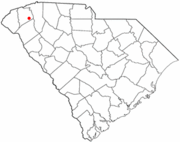
Easley, South Carolina
| Easley, South Carolina | ||
|---|---|---|
| City | ||
| ||
| Motto: Time Well Spent | ||
 | ||
| Coordinates: 34°49′24″N 82°35′25″W / 34.82333°N 82.59028°WCoordinates: 34°49′24″N 82°35′25″W / 34.82333°N 82.59028°W | ||
| Country | United States | |
| State | South Carolina | |
| Counties | Pickens, partially Anderson | |
| Established | 1874 | |
| Incorporated | 1901 | |
| Government | ||
| • Mayor[1] | Larry Bagwell | |
| • Police Chief | Danny Traber | |
| • Fire Chief | Butch Womack | |
| Area | ||
| • Total | 12.3 sq mi (31.8 km2) | |
| • Land | 12.2 sq mi (31.7 km2) | |
| • Water | 0.04 sq mi (0.1 km2) | |
| Elevation | 1,079 ft (329 m) | |
| Population (2012)[2] | ||
| • Total | 20,098 | |
| • Density | 1,631/sq mi (629.8/km2) | |
| Time zone | Eastern (EST) (UTC-5) | |
| • Summer (DST) | EDT (UTC-4) | |
| ZIP codes | 29640-29642 | |
| Area code(s) | 864 | |
| FIPS code | 45-21985 | |
| GNIS feature ID | 1247594[3] | |
| Website | www.cityofeasley.net | |
Easley is a small city in Pickens County (with parts extending into Anderson County) in the State of South Carolina. It is a principal city of the Greenville–Mauldin–Easley Metropolitan Statistical Area. Most of the city lies in Pickens County, with only a very small portion of the city in Anderson County. The population was 19,993 at the 2010 census.[2]
Easley has been hosting the Big League World Series for several years. The Upper South Carolina State Fair is located about 2 miles (3 km) east of Easley.
Geography
Easley is located in southeastern Pickens County at 34°49′24″N 82°35′25″W / 34.82333°N 82.59028°W (34.823371, -82.590394)[4], 12 miles (19 km) west of the center of Greenville.
According to the United States Census Bureau, the city has a total area of 12.3 square miles (31.8 km2), of which 12.2 square miles (31.7 km2) is land and 0.039 square miles (0.1 km2), or 0.17%, is water.[5]
Larry Bagwell is the elected mayor.
Demographics
| Historical population | |||
|---|---|---|---|
| Census | Pop. | %± | |
| 1880 | 327 | ||
| 1890 | 421 | 28.7% | |
| 1900 | 903 | 114.5% | |
| 1910 | 2,983 | 230.3% | |
| 1920 | 3,568 | 19.6% | |
| 1930 | 4,886 | 36.9% | |
| 1940 | 5,183 | 6.1% | |
| 1950 | 6,316 | 21.9% | |
| 1960 | 8,283 | 31.1% | |
| 1970 | 11,175 | 34.9% | |
| 1980 | 14,264 | 27.6% | |
| 1990 | 15,195 | 6.5% | |
| 2000 | 17,754 | 16.8% | |
| 2010 | 19,993 | 12.6% | |
| Est. 2012 | 20,098 | 0.5% | |
2012 Estimate[7] | |||
As of the census of 2000, there were 17,754 people, 7,227 households, and 5,058 families residing in the city. The population density was 1,668.8 people per square mile (644.3/km²). There were 7,932 housing units at an average density of 745.6 per square mile (287.8/km²). The racial makeup of the city was 85.35% White, 11.81% African American, 0.14% Native American, 0.52% Asian, 0.03% Pacific Islander, 1.25% from other races, and 0.90% from two or more races. Hispanic or Latino of any race were 2.82% of the population.
There were 7,227 households out of which 30.6% had children under the age of 18 living with them, 53.9% were married couples living together, 12.3% had a female householder with no husband present, and 30.0% were non-families. 25.7% of all households were made up of individuals and 11.0% had someone living alone who was 65 years of age or older. The average household size was 2.43 and the average family size was 2.90.
In the city the population was spread out with 23.5% under the age of 18, 8.5% from 18 to 24, 29.7% from 25 to 44, 23.6% from 45 to 64, and 14.7% who were 65 years of age or older. The median age was 37 years. For every 100 females there were 92.1 males. For every 100 females age 18 and over, there were 88.6 males.
The median income for a household in the city was $38,204, and the median income for a family was $47,867. Males had a median income of $35,399 versus $25,443 for females. The per capita income for the city was $20,965. About 8.4% of families and 10.9% of the population were below the poverty line, including 12.2% of those under age 18 and 11.9% of those age 65 or over.
History
What was first named Rockville in 1791 became Pickensville the next year and, later, Easley in the late 1800s. During its short history, Pickensville played a major role in the development of upstate South Carolina. In 1792 it held the distinction of being the district seat for Washington District, which was composed of Greenville and Pendleton counties. In 1798 the Washington District was divided into the Greenville and Pendleton districts, with Pickensville maintaining its place as the district seat for Pendleton. Pendleton District was composed of what would later be known as Pickens, Anderson, and Oconee counties.
When a new courthouse was built in Pendleton for the Court of General Sessions and Common Pleas, the importance of Pickensville began to wane. The ultimate demise came when the railroad located through Easley, a scant 2 miles (3 km) away. The state granted a charter for Easley in January 1874. The next year (1875), the US Post Office Department renamed the Pickensville Post Office, which had opened in 1795, to the Easley Post Office.
Pickensville and Pickens County were named after General Andrew Pickens of Revolutionary War fame. Easley's namesake was General William King Easley who fought for the Confederacy during the Civil War. General Easley was an attorney for the Atlanta and Charlotte Railroad Company, which owned the railroad that passed through Easley. Robert Elliot Holcombe, who became the first mayor of Easley, financed and built the first depot in town.
Notable people
- Kimberly Hampton, U.S. Army captain, first female military pilot to be killed by hostile fire
- Stanley Morgan, National Football League player for the New England Patriots
- Wes Knight, Major League Soccer player for the Vancouver Whitecaps FC
References
- ↑ "Your Government Representatives". 2007-05-06.
- ↑ 2.0 2.1 "2010 Census Redistricting Data (Public Law 94-171) Summary File". American FactFinder. United States Census Bureau. Retrieved 5 June 2012.
- ↑ "US Board on Geographic Names". United States Geological Survey. 2007-10-25. Retrieved 2008-01-31.
- ↑ "US Gazetteer files: 2010, 2000, and 1990". United States Census Bureau. 2011-02-12. Retrieved 2011-04-23.
- ↑ "Geographic Identifiers: 2010 Demographic Profile Data (G001): Easley city, South Carolina". U.S. Census Bureau, American Factfinder. Retrieved August 7, 2013.
- ↑ United States Census Bureau. "Census of Population and Housing". Retrieved November 12, 2013.
- ↑ "Annual Estimates of the Resident Population: April 1, 2010 to July 1, 2012". Retrieved November 12, 2013.
External links
| |||||||||||||||||||||||
| |||||||||||||||||||||||


