Dzheyrakhsky District
| Dzheyrakhsky District Джейрахский район (Russian) Жӏайраха шахьар (Ingush) | |
|---|---|
.svg.png) Location of Dzheyrakhsky District in the Republic of Ingushetia | |
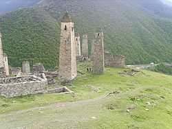 Defense towers in the selo of Erzi in Dzheyrakhsky District | |
| Location | |
| Country | Russia |
| Federal subject | Republic of Ingushetia[1] |
| Administrative structure (as of 2010) | |
| Administrative center | selo of Dzheyrakh[1] |
| Inhabited localities:[citation needed] | |
| Rural localities | 85 |
| Municipal structure (as of March 2010) | |
| Municipally incorporated as | Dzheyrakhsky Municipal District[2] |
| Municipal divisions:[2] | |
| Urban settlements | 0 |
| Rural settlements | 5 |
| Statistics | |
| Area | 628.14 km2 (242.53 sq mi)[3] |
| Population (2010 Census) | 2,638 inhabitants[1] |
| - Urban | 0% |
| - Rural | 100% |
| Density | 4.2 /km2 (11 /sq mi)[4] |
| Time zone | MSK (UTC+04:00)[5] |
| Established | 1993[citation needed] |
| Dzheyrakhsky District on WikiCommons | |
Dzheyrakhsky District (Russian: Джейра́хский райо́н; Ingush: Жӏайраха шахьар) is an administrative[citation needed] and municipal[2] district (raion), one of the four in the Republic of Ingushetia, Russia. It is located in the south of the republic. The area of the district is 628.14 kilometers (390.31 mi).[3] Its administrative center is the rural locality (a selo) of Dzheyrakh.[1] Population: 2,638 (2010 Census);[1] 2,334 (2002 Census).[6] The population of Dzheyrakh accounts for 57.4% of the district's total population.[1]
History
The district was established in 1993.[citation needed]
Culture
The Dzheyrakh-Assin historical and architectural museum and nature reserve, including Tkhaba-Yerdy Church, is located in the district.
References
Notes
- ↑ 1.0 1.1 1.2 1.3 1.4 1.5 "Всероссийская перепись населения 2010 года. Том 1" [2010 All-Russian Population Census, vol. 1]. Всероссийская перепись населения 2010 года (2010 All-Russia Population Census) (in Russian). Federal State Statistics Service. 2011. Retrieved June 29, 2012.
- ↑ 2.0 2.1 2.2 Law #5-RZ
- ↑ 3.0 3.1 Official website of the Republic of Ingushetia. Dzheyrakhsky District: Yesterday, Today, Tomorrow (Russian)
- ↑ The value of density was calculated automatically by dividing the 2010 Census population by the area specified in the infobox. Please note that this value may not be accurate as the area specified in the infobox does not necessarily correspond to the area of the entity proper or is reported for the same year as the population.
- ↑ Правительство Российской Федерации. Постановление №725 от 31 августа 2011 г. «О составе территорий, образующих каждую часовую зону, и порядке исчисления времени в часовых зонах, а также о признании утратившими силу отдельных Постановлений Правительства Российской Федерации». Вступил в силу по истечении 7 дней после дня официального опубликования. Опубликован: "Российская Газета", №197, 6 сентября 2011 г. (Government of the Russian Federation. Resolution #725 of August 31, 2011 On the Composition of the Territories Included into Each Time Zone and on the Procedures of Timekeeping in the Time Zones, as Well as on Abrogation of Several Resolutions of the Government of the Russian Federation. Effective as of after 7 days following the day of the official publication.).
- ↑ "Численность населения России, субъектов Российской Федерации в составе федеральных округов, районов, городских поселений, сельских населённых пунктов – районных центров и сельских населённых пунктов с населением 3 тысячи и более человек" [Population of Russia, its federal districts, federal subjects, districts, urban localities, rural localities—administrative centers, and rural localities with population of over 3,000]. Всероссийская перепись населения 2002 года (All-Russia Population Census of 2002) (in Russian). Federal State Statistics Service. May 21, 2004. Retrieved February 9, 2012.
Sources
- Народное Собрание Республики Ингушетия. Закон №5-РЗ от 23 февраля 2009 г. «Об установлении границ муниципальных образований Республики Ингушетия и наделении их статусом сельского поселения, муниципального района и городского округа», в ред. Закона №19-РЗ от 29 марта 2010 г «О внесении изменений в Закон Республики Ингушетия "Об установлении границ муниципальных образований Республики Ингушетия и наделении их статусом сельского поселения, муниципального района и городского округа"». Вступил в силу со дня официального опубликования. Опубликован: "Ингушетия", №26–27, 3 марта 2009 г. (People's Assembly of the Republic of Ingushetia. Law #5-RZ of February 23, 2009 On Establishing the Borders of the Municipal Formations of the Republic of Ingushetia and on Granting Them the Status of a Rural Settlement, Municipal District, and Urban Okrug, as amended by the Law #19-RZ of March 29, 2010 On Amending the Law of the Republic of Ingushetia "On Establishing the Borders of the Municipal Formations of the Republic of Ingushetia and on Granting Them the Status of a Rural Settlement, Municipal District, and Urban Okrug". Effective as of the day of the official publication.).
| |||||||||||||||||
Coordinates: 42°49′19″N 44°40′47″E / 42.82194°N 44.67972°E