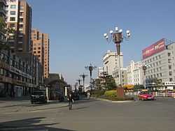
Dunhua
| Dunhua 敦化 · 돈화 | |
|---|---|
| County-level city | |
敦化市 · 돈화시 | |
 | |
 Dunhua | |
| Coordinates: 43°22′N 128°14′E / 43.367°N 128.233°ECoordinates: 43°22′N 128°14′E / 43.367°N 128.233°E | |
| Country | People's Republic of China |
| Province | Jilin |
| Prefecture | Yanbian |
| Seat | Minzhu Subdistrict |
| Area | |
| • Total | 11,963 km2 (4,619 sq mi) |
| Elevation | 505 m (1,657 ft) |
| Population | |
| • Total | 480,000 |
| • Density | 40/km2 (100/sq mi) |
| Time zone | China Standard (UTC+8) |
| Postal code | 133700 |
| Area code(s) | 0433 |
| Dunhua | |||||||
| Chinese | 敦化市 | ||||||
|---|---|---|---|---|---|---|---|
| |||||||
| Chinese Korean name | |||||||
| Chosŏn'gŭl | 돈화시 | ||||||
| |||||||
| South Korean name | |||||||
| Hangul | 둔화 시 | ||||||
| |||||||
Dunhua is a county-level city of the Yanbian Korean Autonomous Prefecture in southeastern Jilin province, People's Republic of China. It has more than 480,000 inhabitants (as of 2002) and was the capital of Balhae between 742−756, known at the time as "Junggyeong". During the Qing Dynasty it was called Áodōng (敖东) in Chinese and Odoli in Manchu.[1]
Geography and climate
Dunhua is situated amongst the Changbai Mountains, its administrative area spanning 42°42′−44°30′ N latitude and 127°28′−129°13′ E longitude, reaching a maximal north-south extent of 200 km (124 mi) and east-west width of 142 km (88 mi). Its total area of 11,957 km2 (4,617 sq mi) makes it, by area, the largest county-level city of the province.
Dunhua has a four-season, monsoon-influenced, humid continental climate (Köppen Dwb), with long, very cold winters, and short, but warm, humid summers. Spring and autumn constitute very short transitions with some, but usually not heavy, rainfall. The monthly 24-hour average temperature ranges from −16.6 °C (2.1 °F) in January to 20.1 °C (68.2 °F) in July, while the annual mean is 3.28 °C (37.9 °F) and a total precipitation of 632 mm (24.9 in), more than 60% of which falls from June through August.
| Climate data for Dunhua (1971−2000) | |||||||||||||
|---|---|---|---|---|---|---|---|---|---|---|---|---|---|
| Month | Jan | Feb | Mar | Apr | May | Jun | Jul | Aug | Sep | Oct | Nov | Dec | Year |
| Average high °C (°F) | −9.5 (14.9) |
−5.6 (21.9) |
2.0 (35.6) |
12.2 (54) |
19.3 (66.7) |
23.0 (73.4) |
25.5 (77.9) |
24.6 (76.3) |
19.5 (67.1) |
12.0 (53.6) |
1.4 (34.5) |
−6.6 (20.1) |
9.8 (49.7) |
| Average low °C (°F) | −22.8 (−9) |
−19.2 (−2.6) |
−10.7 (12.7) |
−1.1 (30) |
5.3 (41.5) |
11.3 (52.3) |
15.6 (60.1) |
14.5 (58.1) |
6.6 (43.9) |
−1.5 (29.3) |
−10.2 (13.6) |
−18.7 (−1.7) |
−2.6 (27.4) |
| Precipitation mm (inches) | 4.8 (0.189) |
4.8 (0.189) |
11.9 (0.469) |
29.0 (1.142) |
59.7 (2.35) |
116.1 (4.571) |
151.8 (5.976) |
138.0 (5.433) |
65.4 (2.575) |
28.8 (1.134) |
14.8 (0.583) |
6.6 (0.26) |
631.7 (24.871) |
| Avg. precipitation days (≥ 0.1 mm) | 5.3 | 5.6 | 7.3 | 10.1 | 12.6 | 16.2 | 16.2 | 15.4 | 11.2 | 8.5 | 8.0 | 6.6 | 123.0 |
| Source: Weather China | |||||||||||||
Administrative divisions
Dunhua has four subdistricts, 11 towns, and 5 townships.[2]
Subdistricts:
- Minzhu Subdistrict (民主街道 / 민주가도), Bohai Subdistrict (渤海街道 / 발해가도), Shengli Subdistrict (胜利街道 / 승리가도), Danjiang Subdistrict (丹江街道 / 단강가도)
Towns:
- Dashitou (大石头镇 / 대석두진), Huangnihe (黄泥河镇 / 황니하진), Guandi (官地镇 / 관지진), Shaheyan (沙河沿镇 / 사하연진), Qiuligou (秋梨沟镇 / 추리구진), Aegmog (额穆镇 / 액목진), Xianru (贤儒镇 / 현유진), Dapuchaihe (大蒲柴河镇 / 대포채하진), Yanminghu (雁鸣湖镇 / 안명호진), Jiangyuan (江源镇 / 강원진), Jiangnan (江南镇 / 강남진)
Townships:
- Daqiao Township (大桥乡 / 대교향), Heishi Township (黑石乡 / 흑석향), Qinggouzi Township (青沟子乡 / 청구자향), Hanzhang Township (翰章乡 / 한장향), Hongshi Township (红石乡 / 홍석향)
Sister cities
- *
 Dongjak-gu, Seoul of South Korea (1968)[3]
References
- ↑ http://baike.baidu.com/view/6787.htm
- ↑ "延边朝鲜族自治州-行政区划网 www.xzqh.org" (in Simplified Chinese). xzqh.org. Retrieved 2011-04-28.
- ↑ ¢Æ Μ¿Àû±¸ ȨÆäàìáö¿¡ ¿À½Å °Í໠ȯ¿Μçõ´Ï´Ù ¢Æ
External links
| |||||||||||||