Dunajec


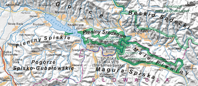
The Dunajec is a river running through southern Poland. It is the right tributary of the Vistula River. It begins in Nowy Targ at the junction of two short mountain rivers, Czarny Dunajec and Biały Dunajec (Black and White Dunajec). Dunajec forms a border between Poland and Slovakia for 27 kilometers in the Pieniny Środkowe (Slovak: Centrálne Pieniny) range, east of the Czorsztyn reservoir. It is the only river taking waters from the Slovak territory to the Baltic Sea.
The Dunajec is 274 kilometers long, running through southern Poland for 247 kilometers, which makes it Poland's fourteenth longest river. It has a basin area of 6,804 square kilometres (4,852 in Poland, and 1,952 in Slovakia). On the Slovak/Polish border, it flows through the Zamagurie region, with attractions such as the Dunajec River Gorge, the Trzy Korony massif with a 500 metres (1,600 ft) precipice, Červený Kláštor, and two Pieniny castles in Czorsztyn and Niedzica.
Below the two source streams Dunajec flows through a broad valley called Nowotarska Basin. It then supplies the waters of the dam in Niedzica (Jezioro Czorsztyńskie Lake) and the dam in Sromowce Wyżne (Sromowce Wyżne reservoir). Flowing through the central part of the Pieniny range, it creates a picturesque turn at the Polish Slovak border between Sromowce Wyżne and Szczawnica. Further down it turns to the north into the Western Beskid Mountains, and Sądecka Basin (where it merges with its own largest tributary, the Poprad river). It flows across an open valley of the Beskid Foothills and falls down across Rożnów Foothills (with two more dams: the Jezioro Rożnowskie Lake, and Jezioro Czchowskie Lake) and finally, it leads into the Sandomierz Basin and the valley of Vistula Lowlands. Dunajec flows into the Vistula River in the vicinity of Opatowiec.
Towns and townships
The Dunajec flows through or near these locations:
|
|
See also
| Wikimedia Commons has media related to Dunajec. |
- Dunajec River Gorge
- Rivers of Poland
- Rivers of Slovakia
- 1934 flood in Poland
- Dunajec river castles
References
Coordinates: 50°14′35″N 20°43′42″E / 50.2431°N 20.7283°E
| ||||||||||||||
