Duarte Province
| Duarte | |
| Province | |
| Country | |
|---|---|
| Capital | San Francisco de Macorís |
| - elevation | 110 m (361 ft) |
| - coordinates | 19°18′0″N 70°15′0″W / 19.30000°N 70.25000°W |
| Area | 1,605.35 km2 (620 sq mi) |
| Population | 289,574 (2010) [1] |
| Density | 180 / km2 (466 / sq mi) |
| Province since | 1896 |
| Subdivisions | 7 municipalities 11 municipal districts |
| Congresspersons | 1 Senator 6 Deputies |
| Timezone | EST (UTC-4) |
| Area code | 1-809 1-829 1-849 |
| ISO 3166-2 | DO-06 |
| Postal Code | 31000 |
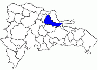 Location of the Duarte Province
| |
Duarte (Spanish pronunciation: [ˈdwarte]) is a province of the Dominican Republic. It is named after Juan Pablo Duarte, founder of the Dominican Republic.
It was created in 1896 as a district (an old country subdivision) with the name Distrito Pacificador but the Constitution of 1907 changed the category to province. In 1925 its name was changed to Duarte.
Geography
The province has a total area of 1,605.35 km².[2] It has 3.3% of the area of the Dominican Republic and it is ranked as the 13th (out of 31 plus the National District) largest province.
Duarte borders with provinces María Trinidad Sánchez, Espaillat and Samaná to the north; with Samaná to the east; with Monte Plata and Sánchez Ramírez to the south; and with Hermanas Mirabal and La Vega to the west.
Municipalities
The province as of June 20, 2006 is divided into the following municipalities (municipios) and municipal districts (distrito municipal - D.M.) within them:[3]
- San Francisco de Macorís, head municipality of the province
- Cenoví (D.M.)
- Jaya (D.M.)
- La Peña (D.M.)
- Presidente Don Antonio Guzmán Fernández (D.M.)
- Arenoso
- El Aguacate (D.M.)
- Las Coles (D.M.)
- Castillo
- Eugenio María de Hostos
- Sabana Grande (D.M.)
- Las Guáranas
- Pimentel
- Villa Riva
- Agua Santa del Yuna (D.M.)
- Barraquito (D.M.)
- Cristo Rey de Guaraguao (D.M.)
- Guáranas Arriba (D.M.)
Population
The following is a sortable table of the municipalities and municipal districts with population figures as of the 2012 census.[4]
| Name | Total population | Urban population | Rural population |
|---|---|---|---|
| Arenoso | 17,589 | 5,989 | 11,600 |
| Castillo | 20,258 | 8,965 | 11,293 |
| Eugenio Maria de Hostos | 14,598 | 7,443 | 7,155 |
| Las Guáranas | 19,969 | 9,985 | 9,984 |
| Pimentel | 35,989 | 25,400 | 10,589 |
| San Francisco de Macorís | 245,397 | 173,033 | 72,364 |
| Villa Riva | 30,989 | 9,635 | 21,354 |
| Duarte province | 384,789 | 240,450 | 144,339 |
For comparison with the municipalities and municipal districts of other provinces see the list of municipalities and municipal districts of the Dominican Republic.
References
- ↑ "IX Censo Nacional de Población y Vivienda 2010." (PDF) (in Spanish). Oficina Nacional de Estadística. June 2012. Retrieved 23 September 2013.
- ↑ Listado de Códigos de Provincias, Municipio y Distritos Municipales, Oficina Nacional de Estadistica
- ↑ Oficina Nacional de Estadística. "División Territorial 2008" (PDF) (in Spanish). Retrieved 2009-10-01.
- ↑ Consejo Nacional de Población y Familia. "Censos y Proyecciones de la Población Dominicana por Regiones, Provincias, Municipios y Distritos Municipales, 2012" (PDF) (in Spanish). Retrieved 2010-10-11.
External links
- (Spanish) Oficina Nacional de Estadística, Statistics Portal of the Dominican Republic
- (Spanish) Oficina Nacional de Estadística, Maps with administrative division of the provinces of the Dominican Republic, downloadable in PDF format