Dobropillia Raion
From Wikipedia, the free encyclopedia
| Dobropils'kyi Raion Добропільський район | |||
|---|---|---|---|
| Raion | |||
| |||
 | |||
| Country |
| ||
| Province | Donetsk Oblast | ||
| Established | N/A | ||
| Admin. center | Dobropillia | ||
| Subdivisions |
List
| ||
| Government | |||
| • Administration | N/A | ||
| Area | |||
| • Total | 949 km2 (366 sq mi) | ||
| Population | |||
| • Total | 20,482 | ||
| • Density | 22/km2 (56/sq mi) | ||
| Time zone | EET (UTC+2) | ||
| • Summer (DST) | EEST (UTC+3) | ||
| Postal index | 873-XX | ||
| Area code | 380 | ||
| Website | Verkhovna Rada website | ||

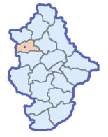
The Dobropillia Raion (Ukrainian: Добропільський район, translit.: Dobropil's'kyi raion; Russian: Добропо́льский район, translit.: Dobropol'skiy raion) is a raion (district) within the southwestern part of Donetsk Oblast in eastern Ukraine. Its administrative center is Dobropillia. Its population is 20,482 and its area is 949 square kilometres.
Within the Dobropillia Raion there is: one urban-type settlement (Svyatohorivka - 2,100 inhabitants), 9 selsovets, and 66 settlements. Also included within the raion are: 17 kolhozy, and 3 sovhozy, 4 industrial organizations, 4 construction organizations, 2 railroad stations, 44 Meduchredzheniy, and 47 libraries.
An architectural monument in the raion is a palace (1887-1914-selo Zelyenoe).
Settlements
- Bilytske
- Bilozerske
- Vodianske
- Volodymyrivka
- Virovka
- Hannivka
- Dobropillia
- Zolotyi Kolodiaz
- Krasnoiarske
- Kryvorizhia
- Novyi Donbas
- Novovodiane
- Novodonetske
- Novotoretske
- Novotroitske
- Novofedorivka
- Oktiabrske
- Rozy Liuksemburh
- Sviatohorivka
- Svitle
- Shevchenko
- Shylivka
See also
- Subdivisions of Ukraine
- Donetsk Oblast
External links
- (Ukrainian) Verkhovna Rada website - Administrative divisions of the Dobropillia Raion
| |||||||||||||||||||||||
This article is issued from Wikipedia. The text is available under the Creative Commons Attribution/Share Alike; additional terms may apply for the media files.

