Doberlug-Kirchhain
| Doberlug-Kirchhain | ||
|---|---|---|
 | ||
| ||
 Doberlug-Kirchhain | ||
Location of Doberlug-Kirchhain within Elbe-Elster district  | ||
| Coordinates: 51°37′N 13°34′E / 51.617°N 13.567°ECoordinates: 51°37′N 13°34′E / 51.617°N 13.567°E | ||
| Country | Germany | |
| State | Brandenburg | |
| District | Elbe-Elster | |
| Subdivisions | 10 Ortsteile | |
| Government | ||
| • Mayor | Bodo Broszinski (FDP) | |
| Area | ||
| • Total | 148.93 km2 (57.50 sq mi) | |
| Elevation | 97 m (318 ft) | |
| Population (2012-12-31)[1] | ||
| • Total | 8,875 | |
| • Density | 60/km2 (150/sq mi) | |
| Time zone | CET/CEST (UTC+1/+2) | |
| Postal codes | 03253 | |
| Dialling codes | 035322 | |
| Vehicle registration | EE | |
| Website | www.doberlug-kirchhain.de | |

Doberlug-Kirchhain is a town in the district of Elbe-Elster, Brandenburg, Germany.
History
937. The town of Kirchhain was built by Margrave Gero. A document written in 1005 mentions the town Doberlug (Dobraluh) for the first time. In 1165 the Cistercian Dobrilugk Abbey was founded by Margrave Dietrich of Landsberg.
1235. Kirchhain received market-rights. In 1431 the Hussites destroyed the town of Doberlug and the abbey was devastated. In 1637 and 1643 the Swedes destroyed Kirchhain.
1848. The jurisdictions of Doberlug and Kirchhain were unified, but the actual merger of the two towns did not take place until over one hundred years later, in 1950.
During World War II, Kirchhain was taken by the Red Army on 23 April 1945.
On August 28, 1992, the Amt Doberlug-Kirchhain was created to streamline the administration of the town together with the surrounding 8 small municipalities. Nexdorf and Frankena later joined as well. The municipalities incorporated into the town were Frankena (2000), Dübrichen, Hennersdorf, Nexdorf, Prießen and Werenzhain (2001), and Buchhain (2002). The remaining three municipalities Arenzhain, Trebbus and Lugau were incorporated on October 26, 2003, thus ending the history of the Amt.
Demography
-
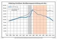
Development of Population since 1875 within the Actual Boundaries (Blue Line: Population; Dotted Line: Comparison to Population Development of Brandenburg state; Grey Background: Time of Nazi rule; Red Background: Time of Communist rule)
-
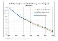
Recent Population Development (Blue Line) and Forecasts
|
|
|
|
Detailed data sources are to be found in the Wikimedia Commons.[3]
Coat of arms
The coat of arms of the town shows the town hall with three towers topped with yellow flags. Below is a green ring. On top are two clouds and rays of the sun. The shield is blue, and shaped like a leather sheet, symbolizing the history of the city as a tannery center. The coat of arms was created in 1950 by combining the symbols of the coats of arms of Doberlug and Kirchhain: the green ring and the sun are taken from the arms of Doberlug, while the town hall is from those of Kirchhain.
Twin towns
Doberlug-Kirchhain is twinned with Hemer in North Rhine-Westphalia and Kirchhain in Hesse.
Notable natives and residents
Kirchhain
- Daniel Schade (1601–1662), Musician
- Karl Gustav von Berneck (1803–1871), writer
- Guido Jendritzko (* 1925), sculptor and painter
- Catrin Große (* 1964 in Finsterwalde), painter, graphic designer and sculptor
Doberlug
- Heinrich Clauren (1771–1854), also Carl Gottlieb Samuel Heun, writer
- Otto Fridolin Fritzsche (1812–1896), theologist
- Hermann Wilhelm Vogel (1834–1898), chemist
- Eduard Köllner, (1839–1891), composer of Festhymne zur 100 jährigen Jubelfeier der Unabhängigkeitserklärung der Vereinigten Staaten Nordamerikas (Hymn for the Independence Day 1876)
Photogallery
-
The town in the Kreis Elbe-Elster
-
.jpg)
Church Gate of Dobrilugk Abbey
-
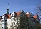
Castle of Doberlug in March 2007
References
- ↑ "Bevölkerung im Land Brandenburg nach amtsfreien Gemeinden, Ämtern und Gemeinden 31. Dezember 2012 (XLS-Datei; 83 KB) (Einwohnerzahlen auf Grundlage des Zensus 2011)". Amt für Statistik Berlin-Brandenburg (in German). 31 December 2012.
- ↑ Boundaries as of 2013
- ↑ Population Projection Brandenburg at Wikimedia Commons
External links
![]() Media related to Doberlug-Kirchhain at Wikimedia Commons
Media related to Doberlug-Kirchhain at Wikimedia Commons