Djúpivogur
From Wikipedia, the free encyclopedia
| Djúpivogur | |
|---|---|
| Town | |
 | |
 | |
 Djúpivogur | |
| Coordinates: 64°39′N 14°17′W / 64.650°N 14.283°W | |
| Country |
|
| Constituency[1] | Norðausturkjördæmi |
| Region[2] | Austurland |
| County | Suður-Múlasýsla |
| Municipality | Djúpavogshreppur |
| Population (2011) | |
| • Total | 352 |
| Time zone | GMT (UTC+0) |
| Website | Official website |

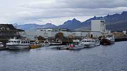
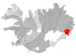
Djúpivogur is a small town and municipality (Djúpavogshreppur) located on a peninsula in eastern Iceland, near the island of Papey and on the fjord Berufjörður. As of 2011, it has a population of 352.
The town is famous in Iceland for being the place with the highest temperature ever recorded in the island. 30.5 °C (87 °F) in June 1939.
Climate
| Climate data for Djupivogur | |||||||||||||
|---|---|---|---|---|---|---|---|---|---|---|---|---|---|
| Month | Jan | Feb | Mar | Apr | May | Jun | Jul | Aug | Sep | Oct | Nov | Dec | Year |
| Average high °C (°F) | 3 (37) |
3 (37) |
4 (39) |
6 (43) |
10 (50) |
13 (56) |
14 (58) |
14 (57) |
11 (52) |
7 (45) |
4 (40) |
3 (38) |
7.7 (46) |
| Average low °C (°F) | −2 (29) |
−2 (28) |
−2 (29) |
−1 (31) |
3 (37) |
6 (42) |
7 (45) |
7 (45) |
5 (41) |
2 (35) |
−1 (31) |
−2 (29) |
1.7 (35.2) |
| Precipitation cm (inches) | 15 (6) |
11.4 (4.5) |
9.1 (3.6) |
8.4 (3.3) |
7.9 (3.1) |
7.9 (3.1) |
9.1 (3.6) |
9.9 (3.9) |
13 (5.1) |
12.4 (4.9) |
12.2 (4.8) |
14.5 (5.7) |
130.8 (51.6) |
| Source: Weatherbase [3] | |||||||||||||
See also
References
- ↑ Political division
- ↑ Mainly statistical division
- ↑ "Weatherbase: Historical Weather for Djupivogur, Iceland". Weatherbase. 2011. Retrieved on November 24, 2011.
External links
| Wikimedia Commons has media related to Djúpivogur. |
Coordinates: 64°39′N 14°17′W / 64.650°N 14.283°W
This article is issued from Wikipedia. The text is available under the Creative Commons Attribution/Share Alike; additional terms may apply for the media files.