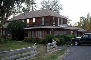
Diamond, Oregon
From Wikipedia, the free encyclopedia
| Diamond, Oregon | |
|---|---|
| Unincorporated community | |
 | |
| Coordinates: 43°00′44″N 118°39′58″W / 43.01222°N 118.66611°WCoordinates: 43°00′44″N 118°39′58″W / 43.01222°N 118.66611°W | |
| Country | United States |
| State | Oregon |
| County | Harney |
| Elevation | 4,219 ft (1,286 m) |
| Time zone | PST (UTC-8) |
| • Summer (DST) | PDT (UTC-7) |
| ZIP codes | 97722 |
| Area code(s) | 541 |
| Coordinates and elevation from United States Geological Survey[1] | |
Diamond is an unincorporated community in Harney County, Oregon, United States. Diamond is located west of Oregon Route 205 and south of Malheur Lake, 52 miles (84 km) south-southeast of Burns by highway.[2] Its post office is assigned ZIP code 97722.[3]
Settled in 1874–75, the community got its name from a diamond-shaped branding iron used by a local cattle rancher.[2]
Climate
According to the Köppen Climate Classification system, Diamond has a semi-arid climate, abbreviated "BSk" on climate maps.[4]
References
- ↑ "Diamond". Geographic Names Information System, U.S. Geological Survey. November 28, 1980. Retrieved August 24, 2009.
- ↑ 2.0 2.1 "Diamond, Oregon". Harney County Chamber of Commerce. 2005–06. Retrieved August 24, 2009.
- ↑ Zip Code Lookup
- ↑ Climate Summary for Diamond, Oregon
| ||||||||||||||||||||
This article is issued from Wikipedia. The text is available under the Creative Commons Attribution/Share Alike; additional terms may apply for the media files.
