Dharampasha Upazila
| Dharampasha ধরমপাশা | |
|---|---|
 | |
| Division | Sylhet Division |
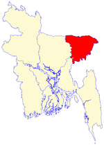
| District | Sunamganj District |
| Area | |
| • Total | 496.03 km2 (191.52 sq mi) |
| Population | |
| • Total | 164,131 |
| • Density | 331/km2 (860/sq mi) |
| Time zone | BST (UTC+6) |
| Postal code | 2450 |
Dharampasha (Bengali: ধরমপাশা) is an Upazila of Sunamganj District in the Division of Sylhet, Bangladesh.
Geography
Dharampasha is located at 24°54′00″N 91°01′00″E / 24.9000°N 91.0167°E . It has 28368 units of house hold and total area 496.03 km². It is located on the banks of the Kangsha River close to the haor areas.The largest haor of Bangladesh called "Tanguar Haor" is located in this upazilla and its neighbouring upazilla Tahirpur.This haor is one of the world heritage sites.
Demographics
As of the 1991 Bangladesh census, Dharampasha has a population of 164131. Males constitute 51.41% of the population, and females 48.59%. This Upazila's eighteen up population is 80347. Dharampasha has an average literacy rate of 20.8% (7+ years), and the national average of 32.4% literate.[1] The neighbouring upazilla are Mohanganj,Barhatta,Kalmakanda,Jamalganj and Tahirpur.
Administrative
Dharampasha has 10 Unions/Wards, 182 Mauzas/Mahallas, and 313 villages. There are 18 Post offices, One Govt. Hospital, One Health Center, One Sub-Health Center and Twenty two community clinics in Dharampasha Upazila.
Market-Places
Dharampasha has 14 famous market places, mostly famous for aggro-products, Domestic animals, sand, stones.
Schools and colleges
- Dharampasha Janata High School (oldest one, Former Khoda-Box Public High school )
- Dharampasha Girls School
- Dharampasha Degree College
- Dharampasha Model Primary School
- Badshaganj Public High School
- Badshaganj Degree College
- Khoda-Box Public High school
- Joysree High School, Joysree
- Modhyanagar B.P. High School and College
- Bongshikonda Momin High School
- Moheskhola High School
- Camardani High School
- Patkura Govt. Primary School
- Rouha Govt. primary School
- Mewhary Govt.primary School
- Kandhapara Govt.primary School
- Camardani Govt.primary School.
See also
- Upazilas of Bangladesh
- Districts of Bangladesh
- Divisions of Bangladesh
References
- ↑ "Population Census Wing, BBS.". Archived from the original on 2005-03-27. Retrieved November 10, 2006.
| ||||||||||||||||||||