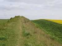
Devil's Dyke, Cambridgeshire


Devil's Dyke (also called Reach Dyke or Devil's Ditch, once known as St Edmund's Ditch) is an earthwork in the English county of Cambridgeshire. It consists of a 7.5 miles (12.1 km) long bank and ditch that runs in a south-east direction from the small village of Reach to nearby Woodditton. It is generally assumed to be an Anglo-Saxon earthwork and is one of the largest and best surviving examples of its kind in England.
Description
Devil's Dyke is over 7 miles (11 km) long and is the largest of a number of ancient Cambridgeshire dykes. In some places the bank measures 9 metres (30 ft) high and 36.5 metres (120 ft) across. Since the 19th century a number of railway lines and roads have been cut through the dyke, including the combined A14 and A11 roads, and a branch line of the Ipswich to Ely rail line.
From Reach, the dyke crosses farmland, before running along the edge of the July Course at Newmarket Racecourse and then through the woods of a private estate near the village of Woodditton.[1]
History
.png)
Devil's Dyke is the largest of several earthworks in south Cambridgeshire that were designed to control movement along the ancient Roman roads. When it was created, it completely blocked a narrow land corridor between the southern edge of a region of water-logged marsh (now known as The Fens) in the north-west and dense woodlands in the south, so making circumvention difficult and forming an effective defensive barrier for the lands to the east. The dyke crossed three important Roman roads, including the ancient Icknield Way, and may thus have served as a way of controlling trade and movement in and out of the area. Findings such as the small quantity of silt in the ditch fills suggest that the dyke fell into disuse soon after it was built.
The other Cambridgeshire dykes include Fleam Dyke, Brent Ditch and Bran ditch. Black Ditches, Cavenham is a fifth earthwork guarding the Icknield Way which is in Suffolk, to the north west of Bury St Edmunds.
Early commentators

The earthwork has been described by various different commentators since Anglo-Saxon times. The Anglo-Saxon Chronicle refers to the Devil's Dyke in its annal for 905, when Edward the Elder is recorded as fighting and defeating the Danes of East Anglia, after first laying waste to the countryside: 'and he laid waste their land between the Dyke and the Ouse as far northward as the Fens'—' and oferhergade call hera land betwuh dicun and Wusan. call oþ da fennas norð' .[2] Abbo of Fleury, writing in the late 10th century, described East Anglia as "fortified in the front with a bank or rampier like unto a huge wall, and with a trench or ditch below in the ground".[3] The mediaeval Flores Historiarum, referred to "...duo fossata sancti Eadmundi..." - 'the two fortifications of St Edmund' - when describing the battle between Edward and his adversaries.[4]
Modern scholarship
Archaeological Carbon-14 dating has concluded that the dyke was reinforced in the late 6th or early 7th century at a time when competition between neighbouring Saxon tribes was particularly fierce. It is believed that the dyke would have been used to demarcate the boundary of a tribe's influence.
There have been a number of excavations and investigations of the Dyke in modern times, including excavations in 1923 and 1991. In 1991, little was found when a small part of the dyke (measuring 8 × 3 metres (26.2 × 9.8 ft)) was excavated prior to the construction of a new aqueduct. The results of a 1988 resistivity survey of the point where Street Way cuts through the dyke were inconclusive.[5]
Heritage
The course of the dyke is now controlled by English Heritage as a Scheduled Ancient Monument, as well as Site of Special Scientific Interest. A well-kept footpath runs the full length of the dyke.
The path is also home to several rare species of flora and is an excellent example of a chalk grassland. Flowers often seen along its route include the Pasque flower Pulsatilla vulgaris, and six species of orchid including the Lizard Orchid. The Chalkhill Blue butterfly can also be found here.
External links
- Devil's Dyke Restoration Project
- 'The Devil's Dyke', from Legends of the Fenland People.
Footnotes
- ↑ Cambridgeshire Historic Environment Record 07801.
- ↑ Earle, Two of the Saxon Chronicles Parallel, pp. lxxi, 98.
- ↑ Tymms, The Devil's Dyke, Newmarket, p. 175.
- ↑ Babington, Ancient Cambridgeshire, p.60.
- ↑ Cambridgeshire HER, 'Devil's Ditch/Dyke'
Sources
- Babington, Cardale (1853). Ancient Cambridgeshire: or an Attempt to Trace Roman and Other Ancient Roads That Passed Through the County of Cambridge. Cambridge: Cambridge University Press.
- "Cambridgeshire Historic Environment Record 07801 (Devil's Ditch/Dyke, Reach to Woodditton)". Heritage Gateway. 2006. Retrieved 27 November 2011.
- Earle, John (1865). Two of the Saxon Chronicles Parallel (in Old English, with notes in English). Oxford: Clarendon Press.
- Fox.C (1923) The archaeology of the Cambridge region: a topographical study of the Bronze, Early Iron, Roman and Anglo-Saxon Ages, with an introductory note on the Neolithic Age. Cambridge: Cambridge University Press
- Tymms, Samuel (1853). 's+dyke&hl=en&ei=RKDKTqyqNNT38QPTy-Bd&sa=X&oi=book_result&ct=book-thumbnail&resnum=6&ved=0CE8Q6wEwBQ#v=twopage&q&f=true "The Devil's Dyke, Newmarket". Proceedings of the Bury and West Suffolk Archaeological Institute (Bury St. Edmunds) 1. Retrieved 21 November 2011.