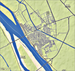
Desouk
Coordinates: 31°8′32″N 30°38′42″E / 31.14222°N 30.64500°E
| Desouk دسوق Disūq | |||
|---|---|---|---|
 Neighborhood of south Desouk · A statue of Ramesses II with Goddess Sekhmet. Presidency of Desouk City · Desouk old bridge (1927). | |||
| |||
| Nickname(s): Bride of the Nile | |||
 | |||
 Desouk | |||
| Coordinates: 31°8′32″N 30°38′42″E / 31.14222°N 30.64500°E | |||
| Country |
| ||
| Governorate | Kafr el-Sheikh | ||
| Government | |||
| • Type | Markaz | ||
| • President | Samir Sallam [1] | ||
| Population (2009) | |||
| • Total | 129,604 | ||
| Time zone | EST (UTC+2) | ||
| ZIP code | 33611 – 33612[2][3] | ||
| Area code(s) | +2 047 | ||
| Website | Presidency of Desouk City | ||
Desouk (Arabic: دسوق Disūq, Egyptian Arabic pronunciation: [dɪˈsuːʔ]) is a city in northern Egypt. Located 80 km east of Alexandria, it belongs to Kafr el-Sheikh Governorate and had a population of 129,604 inhabitants as of 2009.[4]
Overview
Desouk is a member of the Organization of Islamic Capitals and Cities,[5] because there are important Islamic shrines in the city, like The tomb of Saint "Ibrahim El-Desouki" (13th century) is located in the great mosque in the centre of Desouk. His descendants live in Desouk, Alexandria, Cairo, and many live in the UK and USA.[citation needed]
Desouk lies on the Nile, on the eastern banks of the Rosetta branch, where there are only two bridges to enter the city.
Many important Egyptians hail from Desouk: Youssef El-Mansy, Ahmed Zewail,[6] Mohammed Roshdy, Evelyn Ashamallah, and Abdel-Salam Mohammed Nasar, a famous politician in the city.
Climate
Köppen-Geiger climate classification system classifies its climate as hot desert (BWh), as the rest of Egypt.
| Climate data for Desouk | |||||||||||||
|---|---|---|---|---|---|---|---|---|---|---|---|---|---|
| Month | Jan | Feb | Mar | Apr | May | Jun | Jul | Aug | Sep | Oct | Nov | Dec | Year |
| Average high °C (°F) | 17.8 (64) |
18.8 (65.8) |
21.5 (70.7) |
25.3 (77.5) |
29.2 (84.6) |
30.9 (87.6) |
32.2 (90) |
32.3 (90.1) |
30.6 (87.1) |
28.8 (83.8) |
24.6 (76.3) |
19.9 (67.8) |
25.99 (78.77) |
| Daily mean °C (°F) | 12.4 (54.3) |
13.1 (55.6) |
15.4 (59.7) |
18.6 (65.5) |
22.3 (72.1) |
24.6 (76.3) |
26.1 (79) |
26.2 (79.2) |
24.7 (76.5) |
22.8 (73) |
19.1 (66.4) |
14.5 (58.1) |
19.98 (67.98) |
| Average low °C (°F) | 7 (45) |
7.4 (45.3) |
9.3 (48.7) |
11.9 (53.4) |
15.4 (59.7) |
18.4 (65.1) |
20.1 (68.2) |
20.2 (68.4) |
18.8 (65.8) |
16.8 (62.2) |
13.6 (56.5) |
9.1 (48.4) |
14 (57.23) |
| Precipitation mm (inches) | 26 (1.02) |
20 (0.79) |
9 (0.35) |
4 (0.16) |
3 (0.12) |
0 (0) |
0 (0) |
0 (0) |
0 (0) |
6 (0.24) |
13 (0.51) |
23 (0.91) |
104 (4.1) |
| Source: Climate-Data.org[7] | |||||||||||||
See also
- Buto
- Desouk SC
- Desouk Stadium
- Desouki
- Kafr el-Sheikh
- Kafr el-Sheikh Governorate
- Alexandria
- Desouk Bridge
References
- ↑ "غباشى" رئيس مدينة دسوق الضحية السابعة بين رؤساء المدن لمحافظ كفر الشيخ. صدى البلد، بتاريخ 14 مارس 2013. تاريخ الوصول: 5 أبريل 2013.
- ↑ "ZIP code, Desouk (1)". Epcodes.com. Retrieved 2010-12-28.
- ↑ "ZIP code, Desouk (2)". Epcodes.com. Retrieved 2010-12-28.
- ↑ "Presidency of Desouk City, Administrative division & Population (2009)". Epcodes.com. 2009-12-31. Retrieved 2010-12-29.
- ↑ "Organization of Islamic Capitals and Cities, Membership". http://www.oicc.org. Retrieved 2010-12-29.
- ↑ "Egyptian figures, Ahmed H. Zewail". sis.gov.eg. Retrieved 2010-12-28.
- ↑ "Climate: Disuq - Climate graph, Temperature graph, Climate table". Climate-Data.org. Retrieved 14 August 2013.
External links
| Wikimedia Commons has media related to Desouk. |
- The official site of Presidency of Desouk City (Arabic)
- The official site of Kafr el-Sheikh Governorate (Arabic, English)
| |||||

