Denali State Park
From Wikipedia, the free encyclopedia
| Denali State Park | |
|---|---|
 Byers Lake view of Denali and the Alaska Range | |
| Type | Wilderness |
| Location |
147.1 Parks Highway, north of Trapper Creek[1] Matanuska-Susitna Borough, Alaska, USA |
| Coordinates | 62°46′12″N 150°03′12″W / 62.77000°N 150.05333°WCoordinates: 62°46′12″N 150°03′12″W / 62.77000°N 150.05333°W[2] |
| Area | 325,240 acres (131,620 ha) |
| Created |
1970 (expanded to present size in 1976) |
| Operated by | Alaska State Parks |
Denali State Park is a 325,240-acre (131,620 ha) state park in the U.S. state of Alaska. It is located adjacent in the Matanuska-Susitna Borough [3]to the east side of Denali National Park and Preserve, along the Parks Highway.

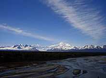
View of Alaska Range from Denali State Park
The park is undeveloped wilderness with the exception of the two day-use areas, three campgrounds, and two trailheads accessible from the Parks Highway.[1]
- Alaska Veterans Memorial
- Denali Viewpoint South
- Byers Lake Campground, near Byers Lake
- Denali Viewpoint North Campground
- Lower Troublesome Creek Campground
- Upper Troublesome Creek Trail (closed in 2009 due to washouts caused by severe flooding)[4]
- Little Coal Creek Trail
See also
References
- ↑ 1.0 1.1 Alaska State Parks near Trapper Creek in the Susitna Valley
- ↑ Denali National Park and Preserve - Aviation Reporting Coordinates (U.S. National Park Service)
- ↑ U.S. Geological Survey Geographic Names Information System: Denali State Park
- ↑ The Milepost 61st Edition, page 406 ISBN 978-1892-15426-2
External links
This article is issued from Wikipedia. The text is available under the Creative Commons Attribution/Share Alike; additional terms may apply for the media files.