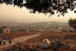
Deir Ghazaleh
| Deir Ghazaleh | |
|---|---|
| Other transcription(s) | |
| • Arabic | دير غزالة |
| • Also spelled |
Deir Ghazala (official) Dayr Ghazzalah (unofficial) |
 | |
 Deir Ghazaleh | |
| Coordinates: 32°29′46.89″N 35°21′01.88″E / 32.4963583°N 35.3505222°ECoordinates: 32°29′46.89″N 35°21′01.88″E / 32.4963583°N 35.3505222°E | |
| Governorate | Jenin |
| Government | |
| • Type | Local Development Committee |
| Area | |
| • Jurisdiction | 6,588 dunams (6.6 km2 or 2.5 sq mi) |
| Population (2006) | |
| • Jurisdiction | 850 |
| Name meaning | "Monastery of the gazelle" |
Deir Ghazaleh (Arabic: دير غزالة) is a Palestinian village in the northern West Bank, located nine kilometers northeast of Jenin in the Jenin Governorate. According to the Palestinian Central Bureau of Statistics, Deir Ghazaleh had a population of over 850 inhabitants in mid-year 2006, mostly Muslims with a large Christian minority.[1]
Water sources
The main source of water is the large groundwater aquifer underlying the West Bank.[2] A well on the outskirts of the village, called the Abu ´Ahed well, supplies water to the village and surrounding communities.[3]
Education and culture
A library was established in Deir Ghazaleh under the auspices of the Program for the Social Empowerment of Rural Women.[4] The Deir Ghazaleh Women’s club, established in 1997, offers training course and workshops for local women.[5]
References
| Wikimedia Commons has media related to Deir Ghazaleh. |
- ↑ Projected Mid -Year Population for Jenin Governorate by Locality 2004- 2006 Palestinian Central Bureau of Statistics
- ↑ PMC - Permanent Issues - Water
- ↑ Field Reports: Occupied Palestinian Territory, OPT: Water and Sanitation, Hygiene Monitoring Project - Summary Report # 8 (Jan, Feb, and Mar 2004)
- ↑ PARC Agricultural Development Association
- ↑ The Rural Women's Development Society
| |||||||||||||
