Deal Castle

Deal Castle is a 16th-century coastal artillery fort, located in Deal, Kent, England, between Walmer Castle and the now lost Sandown Castle (grid reference TR378521).
History
Construction

It is one of the most impressive of the Device Forts or Henrician Castles built by Henry VIII between 1539 and 1540 as an artillery fortress to counter the threat of invasion, brought about by the alliance between Charles V, Holy Roman Emperor and King Francis I of France in 1538. Deal Castle and its smaller neighbours, Walmer and Sandown, were intended to dominate the Downs, a sheltered area of water in the English Channel protected by the Goodwin Sands, which would have been an ideal rallying point for any invasion fleet. The three forts were initially linked by an two mile long earthen "fosse" or rampart, strengthened by three small earth "bulwarks" or forts. These earthworks were sketched by the antiquarian William Stukeley in 1725, but now no trace of them remains.[1] The architect at Deal was probably the Bohemian engineer, Stefan von Haschenperg. The whole scheme for the defence of the Downs was completed by the autumn of 1540.[2]
Anne of Cleves
According to various sources, Anne of Cleves stayed at Deal following her long voyage from Europe. From Deal, Anne left for London and her fateful meeting with King Henry.
Later life
In 1648, during the Civil War, Deal Castle was besieged but after that it never engaged in any further military action. Fortified during the Napoleonic Wars, many alterations were made during the 18th and 19th centuries. The Governor's lodgings were rebuilt at the beginning of the 19th century, only to be destroyed again in 1941 by German bombs in the Second World War. From May 1940 until September 1944, the castle was used as the Battery Observation Post and accommodation for the nearby Deal Emergency Coastal Battery of 6-inch naval guns.[3] It was the official residence of the Captain of the Cinque Ports,[4] but since 1951 has been owned by English Heritage. Castle Community College is named after Deal Castle.
Description

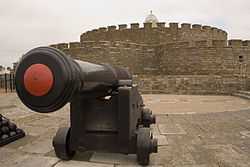
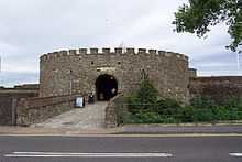
Deal Castle is built of Kentish ragstone brick, and Caen stone taken from nearby religious houses after the Dissolution of the Monasteries. Whether by design or coincidence, the fortress is shaped like a Tudor rose. At the centre is a three-storeyed circular citadel, with six semicircular, slightly lower towers projecting from it. Separated by a narrow ward, a further series of six low semicircular bastions form the curtain wall. The top level of the bastions served as a platform for the heaviest guns. The whole fortress is protected by a stone revetted dry moat, 20m wide and 5m deep. Around the basement level of the bastions, runs a continuous gallery called "the rounds", which is pierced by 53 hand-gun ports or loopholes to allow the defenders to fire into the bottom of the moat. A sally port connects the rounds to the moat floor for counter-attacks. The citadel and outer bastions were originally capped by rounded parapets pierced by embrasures for guns; some of these survive on two bastions on the western side, but most were replaced by ornamental battlements in 1732. The walls originally incorporated up to 145 gun ports on five levels.
The westernmost bastion is taller than the others and serves as a gatehouse. Originally, the moat was crossed by a wooden drawbridge; although this has now been replaced by a stone causeway, the slots for the raising gear are still visible. Once inside the gatehouse, any attacker would have to get past a portcullis, five murder holes set in the ceiling of the large entrance passage, an internal gunport in the back wall opposite the doorway and a staggered approach to the ward. The citadel provided accommodation for the peacetime garrison, originally a captain, deputy, porter and 16 gunners, with the officers living on the upper floor. The ground floor served as a kitchen and bakery; the ovens and fireplace survive. In the centre of the vaulted basement is a large well and was also used to store ammunition and supplies.
Later modifications

Alterations during the early 18th century included the construction of a captain's lodging house within the ward eastern side, the conversion of many of the gun ports of the citadel into casement windows and the building of a wooden lantern, which contains a bell dated 1655, on top of the central tower. In 1802 further alterations were made and the Captain's house was demolished and rebuilt; it was destroyed by a German bomb during World War II. Despite this, Deal Castle has survived well and retains much of its original fabric.[5]
Captains
Since it was first built, Deal Castle has had a Captain. Until the early 18th century, the captain commanded the garrison. However, since that time the title has become purely honorary.
References
- ↑ Dover and Deal Heritage Scheme - Theme 3.4 – The Castles of the Downs: The Henrician Device Forts in Deal and Walmer
- ↑ Adrian Pettifer, English Castles: A Guide by Counties, Boydell Press 1995, ISBN 0-85115-600-2 (9.114
- ↑ English Heritage Monuments Record: Deal Emergency Coastal Battery
- ↑ "Walmer Castle to Deal Castle walk". Kent County Council. Retrieved 2009-02-08.
- ↑ The Gatehouse gazetteer: Deal Castle (English Heritage Scheduling Report)
Further reading
- Coad, Jonathan (1998). Deal Castle, Kent. London: English Heritage. ISBN 1-85074-697-4
- Colvin, H.M. (ed) (1982). The History of the King's Works, Vol. IV, 1485–1600, Part II.
- Fry, Plantagenet Somerset (1980) The David & Charles Book of Castles. David & Charles. ISBN 0-7153-7976-3
- Harrington, Peter (2007). The castles of Henry VIII. Oxford: Osprey. ISBN 978-1-84603-130-4
- Morley, B. M. (1976). Henry VIII and the development of coastal defence. London: H.M. Stationery Office. ISBN 0-11-670777-1
External links
| Wikimedia Commons has media related to Deal Castle. |
- English Heritage site
- Read a detailed historical record of Deal Castle
- Britain Express, brief summary
- Brief history of Deal Castle www.dealweb.org.uk/history-deal/dealcastle.html
- History of Deal Castle & Location & Car parking. Also lots more on the surrounding town.
| |||||||||||
Coordinates: 51°13′07″N 1°24′14″E / 51.21854°N 1.40390°E