DeBary, Florida
| City of DeBary, Florida | ||
|---|---|---|
| City | ||
| ||
| Nickname(s): The River City | ||
 | ||
| Coordinates: 28°52′53″N 81°19′27″W / 28.88139°N 81.32417°WCoordinates: 28°52′53″N 81°19′27″W / 28.88139°N 81.32417°W[1] | ||
| Country | United States | |
| State | Florida | |
| County | Volusia | |
| Incorporated | December 31, 1993 | |
| Government | ||
| • Type | Council–Manager | |
| • Mayor | Bob Garcia | |
| Area[1] | ||
| • City | 21.8 sq mi (56 km2) | |
| • Land | 19.0 sq mi (49 km2) | |
| • Water | 2.8 sq mi (7 km2) | |
| Elevation[2] | 56 ft (17 m) | |
| Population (2010)[3] | ||
| • City | 19,320 | |
| • Density | 1,018.7/sq mi (393.3/km2) | |
| • Urban | 147,713 | |
| • Metro | 494,593 | |
| Time zone | EST (UTC-5) | |
| • Summer (DST) | EDT (UTC-4) | |
| ZIP code(s) | 32713, 32753 | |
| Area code(s) | 386 | |
| FIPS code | 12-16675[3] | |
| GNIS feature ID | 0281364[2] | |
| Website | www.debary.org | |


DeBary is a city in Volusia County, Florida, United States, on the northern shore of the St. Johns River near Lake Monroe. According to the 2010 U.S. Census, the city had a population of 19,320. It is part of the Deltona–Daytona Beach–Ormond Beach Metropolitan Statistical Area, which was home to 494,593 people in 2010.
History
The Timucuan Indians once lived in the vicinity of Lake Monroe, where the domain of Chief Utina extended to just north of Lake George. They hunted, fished and gathered plants and berries from the forest. By 1760, however, the Timucua had disappeared and been replaced by the Seminole tribe from Alabama and Georgia. Florida was acquired from Spain in 1821, but the Seminole Wars would delay settlement. In 1866, Elijah Watson of Enterprise sold land to Oliver and Amanda Arnett on the northern shore of the St. Johns River at Lake Monroe, where they built a house.
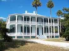
The couple in turn sold 400 acres (1.6 km2) in 1871 to (Samuel) Frederick deBary, a wealthy wine merchant from New York City, and that same year he erected a hunting lodge. Called "DeBary Hall," the 8,000 square foot (700 m²), 20 room Italianate mansion featured a two-tiered veranda, stables, an ice-house and the state's first swimming pool, fed by a spring. Visitors included President Ulysses S. Grant and President Grover Cleveland. Over time he acquired an additional 9,000 acres (36 km2), planting orange groves and pecan trees. There is some debate as to whether this was actually the first pool in Florida, as a St. Augustine pool has also made the same claim. One possibility is that this was the first Spring-fed pool in the state (See Orlando Sentinel article).
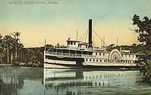
In 1875, deBary bought a small steamboat, the George M. Bird, to transport his horses and dogs along the St. Johns River for hunting expeditions, and also to take fruit to market. He established the DeBary Merchants' Line in 1876, a steamship service contracted to carry mail between Jacksonville and Enterprise. It would acquire the sidewheeler Frederick DeBary. In 1883, the firm merged with the Baya Line, owned by Colonel H.T. Baya, to create the DeBary-Baya Merchants' Line, with 13 steamboats and a crew of 3,000 running to Sanford. The DeBary-Baya Merchants' Line sold its business in 1889 to the Clyde Line, which survived until 1928.
Frederick deBary died in 1898, and his mansion is today a restored museum, listed on the National Register of Historic Places in 1972. The estate, reduced to 10 acres (40,000 m2), now features the community's oldest building, the Arnett House. Incorporated in 1993, the City of DeBary is named for its noted settler.
Geography
DeBary is located at 28°53′03″N 81°18′40″W / 28.884224°N 81.310995°W.[1]
According to the United States Census Bureau, the city has a total area of 21.4 square miles (55 km2). 18.2 square miles (47 km2) of it is land and 3.2 square miles (8.3 km2) of it (15.02%) is water. DeBary is situated on the St. Johns River near Lake Monroe.
Demographics
| Historical population | |||
|---|---|---|---|
| Census | Pop. | %± | |
| 1960 | 2,362 | ||
| 1970 | 3,154 | 33.5% | |
| 1980 | 4,980 | 57.9% | |
| 1990 | 7,176 | 44.1% | |
| 2000 | 15,559 | 116.8% | |
| 2010 | 19,320 | 24.2% | |
| source:[4][5] | |||
As of the census[3] of 2000, there were 15,559 people, 6,538 households, and 4,720 families residing in the city. The population density was 853.8 inhabitants per square mile (329.7/km²). There were 7,001 housing units at an average density of 384.2 per square mile (148.4/km²). The racial makeup of the city was 94.94% White, 1.90% African American, 0.20% Native American, 1.13% Asian, 0.01% Pacific Islander, 0.86% from other races, and 0.96% from two or more races. Hispanic or Latino of any race were 4.15% of the population.
There were 6,538 households out of which 24.8% had children under the age of 18 living with them, 61.1% were married couples living together, 8.5% had a female householder with no husband present, and 27.8% were non-families. 22.7% of all households were made up of individuals and 12.4% had someone living alone who was 65 years of age or older. The average household size was 2.37 and the average family size was 2.76.
In the city the population was spread out with 20.0% under the age of 18, 4.9% from 18 to 24, 24.9% from 25 to 44, 27.2% from 45 to 64, and 23.0% who were 65 years of age or older. The median age was 45 years. For every 100 females there were 92.1 males. For every 100 females age 18 and over, there were 88.3 males.
The median income for a household in the city was $43,364, and the median income for a family was $50,022. Males had a median income of $36,813 versus $25,920 for females. The per capita income for the city was $23,283. About 5.2% of families and 6.9% of the population were below the poverty line, including 8.6% of those under age 18 and 6.4% of those age 65 or over.
Public transportation
DeBary is served by VOTRAN's #23 route. [6]
References
- ↑ 1.0 1.1 1.2 "US Gazetteer files: 2010, 2000, and 1990". United States Census Bureau. 2011-02-12. Retrieved 2011-04-23.
- ↑ 2.0 2.1 "US Board on Geographic Names". United States Geological Survey. 2007-10-25. Retrieved 2008-01-31.
- ↑ 3.0 3.1 3.2 "American FactFinder". United States Census Bureau. Retrieved 2008-01-31.
- ↑ "CENSUS OF POPULATION AND HOUSING (1790-2000)". U.S. Census Bureau. Retrieved 2010-07-17.
- ↑ Census numbers enumerated before 2000 were for DeBary CDP
- ↑ http://www.votran.org/WestVolusia2013b.pdf
External links
| |||||||||||||||||||||||
