Davis Mountains
From Wikipedia, the free encyclopedia
For the Texas wine region around the Davis Mountains, see Texas Davis Mountains AVA.
| Davis Mountains | |
|---|---|
.JPG) Davis Mountains | |
| Highest point | |
| Peak | Baldy Peak atop Mount Livermore |
| Elevation | 8,378 ft (2,554 m) |
| Coordinates | 30°38′N 104°10′W / 30.633°N 104.167°WCoordinates: 30°38′N 104°10′W / 30.633°N 104.167°W |
| Geography | |
| Country | United States |
| State | Texas |
| Geology | |
| Period | Paleogene |
| Type of rock | Igneous |

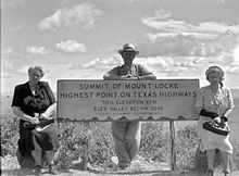
Summit of Mount Locke
Origin and geology
The mountains are of volcanic origin composed of strata associated with eruptions of the Trans-Pecos Texas volcanic field 35 million years ago.[1] The highest peak in the Davis Mountains is Mount Livermore at 8,382 feet, and is the fourth highest peak in Texas.
Conservation
Recently, the The Nature Conservancy has acquired 32,000 acres (130 km²), along with conservation easements on 33,830 acres (136.9 km²) more. This parcel is open to the public at specified times.
Facilities
The McDonald Observatory is located on Mount Locke. It is accessed by Texas State Highway 118 which is the highest state maintained road in Texas at 6,791 feet.

Rolling hills in the Davis Mountains
Climate
| Climate data for Mount Locke weather station, Texas. (Elevation 6,150ft) | |||||||||||||
|---|---|---|---|---|---|---|---|---|---|---|---|---|---|
| Month | Jan | Feb | Mar | Apr | May | Jun | Jul | Aug | Sep | Oct | Nov | Dec | Year |
| Record high °F (°C) | 80 (27) |
79 (26) |
88 (31) |
94 (34) |
96 (36) |
104 (40) |
100 (38) |
104 (40) |
96 (36) |
94 (34) |
82 (28) |
80 (27) |
104 (40) |
| Average high °F (°C) | 53.5 (11.9) |
56.9 (13.8) |
63.7 (17.6) |
71.4 (21.9) |
78.6 (25.9) |
84.5 (29.2) |
82.7 (28.2) |
81.3 (27.4) |
76.6 (24.8) |
70.5 (21.4) |
61.2 (16.2) |
54.4 (12.4) |
69.6 (20.9) |
| Average low °F (°C) | 32.0 (0) |
33.9 (1.1) |
38.2 (3.4) |
45.2 (7.3) |
52.4 (11.3) |
58.2 (14.6) |
58.9 (14.9) |
58.4 (14.7) |
54.4 (12.4) |
48.0 (8.9) |
38.7 (3.7) |
33.6 (0.9) |
46.0 (7.8) |
| Record low °F (°C) | −10 (−23) |
−6 (−21) |
4 (−16) |
11 (−12) |
26 (−3) |
36 (2) |
40 (4) |
40 (4) |
29 (−2) |
13 (−11) |
8 (−13) |
−2 (−19) |
−10 (−23) |
| Precipitation inches (mm) | 0.68 (17.3) |
0.49 (12.4) |
0.40 (10.2) |
0.50 (12.7) |
1.63 (41.4) |
2.49 (63.2) |
3.83 (97.3) |
3.69 (93.7) |
2.95 (74.9) |
1.61 (40.9) |
0.61 (15.5) |
0.60 (15.2) |
19.46 (494.3) |
| Source: The Western Regional Climate Center[2] | |||||||||||||
External links
| Wikimedia Commons has media related to Davis Mountains. |
- Davis Mountains from the Handbook of Texas Online
- Davis Mountains and Indian Lodge - December 5, 2007 - Houston Chronicle
- Davis Mountains photographs, hosted by the Portal to Texas History
- Davis Mountains State Park - Texas Parks and Wildlife
- Davis Mountains Preserve - Nature Conservancy
- U.S. Geological Survey Geographic Names Information System: Davis Mountains
References
- ↑ "40Ar/39Ar chronology and volcanology of silicic volcanism in the Davis Mountains, Trans-Pecos Texas", doi:10.1130/0016-7606(1994)106<1359:AACAVO>2.3.CO;2 Geological Society of America Bulletin November 1994 v. 106 no. 11 p. 1359-1376, accessed September 13, 2010
- ↑ "Seasonal Temperature and Precipitation Information". Western Regional Climate Center. Retrieved April 1, 2013.
This article is issued from Wikipedia. The text is available under the Creative Commons Attribution/Share Alike; additional terms may apply for the media files.