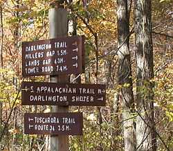
Darlington Trail
| Darlington Trail | |
|---|---|
 The Western Terminus of the Darlington Trail | |
| Established | Early 1900s |
| Length | 7.7 mi (12.4 km) |
| Location | Cumberland / Perry counties, Pennsylvania, USA |
| Trailheads |
West: Appalachian Trail in State Game Land 170 in Pennsylvania East: Tower Road near Marysville, Pennsylvania |
| Use | Hiking |
| Elevation | |
| Highest point | 1,300 ft (400 m) |
| Lowest point | 600 ft (180 m) |
| Hiking details | |
| Hazards | Severe Weather |
| Surface | Varies from very narrow footpath to woods roads; rocky in places |
The Darlington Trail is an orange-blazed hiking trail in Pennsylvania near Harrisburg. It is approximately 7.7 miles (12.4 km) in length.[1] At its western end, it intersects the Tuscarora Trail and the Appalachian Trail. The trail is maintained by the Susquehanna Appalachian Trail Club (SATC).
History
The Darlington Trail predates the Appalachian Trail, and was founded in 1908 by the former Pennsylvania Alpine Club. It was named for the secretary of the club, Bishop Darlington of St. Stephen's Cathedral in Harrisburg. The trail originally ran from Overview, at the Susquehanna River, to the King's Trail west of Chambersburg. The SATC assumed maintenance of the Darlington Trail shortly after its formation in 1954 at the request of the last president of the Alpine Club. Only the portion of the trail that ran from Overview to just west of Sterritts Gap could be located at that time, though.[2]
The Appalachian Trail used a portion of the Darlington Trail right-of-way in the early days of its existence before it was relocated to its present location.[3][4]
References
- ↑ Trail Work, Susquehanna Appalachian Trail Club website
- ↑ Our Favorite Hikes No. 12, Susquehanna Appalachian Trail Club website
- ↑ Transfer of Protected Property, Central Pennsylvania Conservancy Website
- ↑ Appalachian Trail Names, Lillard, Stackpole Books, 2002, ISBN 0-8117-2672-X
External links
- Susquehanna Appalachian Trail Club
- Trail Map PDF (1.1 MB)
Coordinates: 40°18′10″N 77°04′29″W / 40.30269°N 77.07478°W
| |||||||