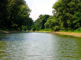
Danube-Auen National Park
From Wikipedia, the free encyclopedia
| Danube-Auen National Park | |
|---|---|
|
IUCN category II (national park) | |
 Danube-Auen near Hainburg | |
 | |
| Location | Vienna and Lower Austria |
| Nearest city | Vienna |
| Coordinates | 48°8′0″N 16°55′0″E / 48.13333°N 16.91667°ECoordinates: 48°8′0″N 16°55′0″E / 48.13333°N 16.91667°E |
| Area | 93 km² |
| Established | October 27, 1996 |
The Danube-Auen National Park (German: Nationalpark Donau-Auen) covers 93 square kilometres in Vienna and Lower Austria and is one of the largest remaining floodplains of the Danube in Middle Europe.
The park was designated an IUCN category II national park and spans the areas of Vienna (Lobau), Groß-Enzersdorf, Orth an der Donau, Eckartsau, Engelhartstetten, Hainburg, Bad Deutsch-Altenburg, Petronell-Carnuntum, Regelsbrunn, Haslau-Maria Ellend, Fischamend and Schwechat.

External links
| Wikimedia Commons has media related to Nationalpark Donau-Auen. |
- www.donauauen.at (English)(German)
| ||||||||
This article is issued from Wikipedia. The text is available under the Creative Commons Attribution/Share Alike; additional terms may apply for the media files.