Dalfsen
From Wikipedia, the free encyclopedia
| Dalfsen | |||
|---|---|---|---|
| Municipality | |||
 | |||
| |||
 | |||
| Coordinates: 52°30′N 06°16′E / 52.500°N 6.267°ECoordinates: 52°30′N 06°16′E / 52.500°N 6.267°E | |||
| Country | Netherlands | ||
| Province | Overijssel | ||
| Area(2006) | |||
| • Total | 166.50 km2 (64.29 sq mi) | ||
| • Land | 165.18 km2 (63.78 sq mi) | ||
| • Water | 1.32 km2 (0.51 sq mi) | ||
| Population (1 January, 2007) | |||
| • Total | 26,558 | ||
| • Density | 161/km2 (420/sq mi) | ||
| Source: CBS, Statline. | |||
| Time zone | CET (UTC+1) | ||
| • Summer (DST) | CEST (UTC+2) | ||
Dalfsen (![]() pronunciation (help·info), Dutch Low Saxon: Dalsen) is a municipality and a town in the Salland region of the Dutch province of Overijssel. The present municipality of Dalfsen was created on 1 January 2001 through the merger of the municipalities of Nieuwleusen and Dalfsen.
pronunciation (help·info), Dutch Low Saxon: Dalsen) is a municipality and a town in the Salland region of the Dutch province of Overijssel. The present municipality of Dalfsen was created on 1 January 2001 through the merger of the municipalities of Nieuwleusen and Dalfsen.
Population centres
Ankum, Dalfsen, Dalfserveld, Dalmsholte, De Marshoek, De Meele, Emmen, Gerner, Hessum, Hoonhorst, Lemelerveld, Lenthe, Leusenerveld, Nieuwleusen, Oudleusen, Oudleusenerveld, Rechteren, Strenkhaar and Welsum.
municipality Dalfsen
-
Dalfsen, view to the town
-
Dalfsen, windmill: de Westermolen
-

Hoonhorst, windmill:molen de Fakkert
Topography

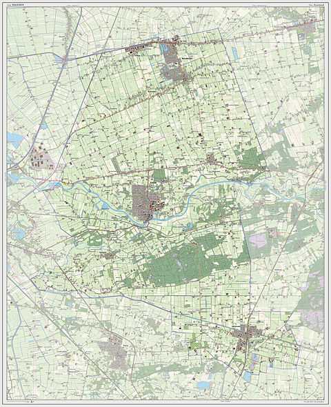
Dutch Topographic map of the municipality of Dalfsen, 2013.
Transportation
External links
| Wikimedia Commons has media related to Dalfsen. |
 |
Staphorst | Hardenberg |  | |
| Zwolle | |
Ommen | ||
| ||||
| | ||||
| Raalte |
| |||||||||||
This article is issued from Wikipedia. The text is available under the Creative Commons Attribution/Share Alike; additional terms may apply for the media files.


