Cuzamá Municipality
From Wikipedia, the free encyclopedia
| Cuzamá | |
|---|---|
| Municipality | |
 | |
 Cuzamá | |
| Coordinates: 20°44′N 89°18′W / 20.733°N 89.300°WCoordinates: 20°44′N 89°18′W / 20.733°N 89.300°W | |
| Country |
|
| State |
|
| Municipal Seat | Cuzamá |
| Mexico Ind. | 1821 |
| Yucatán Est. | 1824 |
| Municipality Founded | 1925 |
| Government | |
| • Type |
|
| • Municipal President | Juan Bautista Kuk Pech[1] |
| Area | |
| • Total | 150.73 km2 (58.20 sq mi) |
| [1] | |
| Elevation | 17 m (56 ft) |
| Population (2005 [2][3]) | |
| • Total | 4,800 |
| • Density | 32/km2 (82/sq mi) |
| Time zone | Central Standard Time (UTC-6) |
| • Summer (DST) | Central Daylight Time (UTC-5) |
| INEGI Code | 015 |
| Major Airport | Merida (Manuel Crescencio Rejón) International Airport |
| IATA Code | MID |
| ICAO Code | MMMD |
| Website | Official Website |
| Municipalities of Yucatan | |
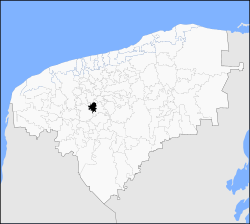
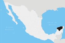
The Municipality of Cuzamá is one of the 106 municipalities in Yucatán state, Mexico. It is located in the east of the state and approximately 26 kilometers east of the city of Merida with its municipal seat located in the City of Cuzamá. The municipality borders to the north the municipalities of Acanceh and Seye, to the south south and east Homun, and to the west Tecoh.[1]
Communities
The municipality is made up of 7 communities as follows:

Cenote de Cuzamá
| Community | Population[4] |
|---|---|
| Entire Municipality | 4,800 |
| Cuzamá | 3,577 |
| Eknakán | 659 |
| Chunkanán | 335 |
| Nohchakán | 175 |
| Chinkilá | 47 |
| Yaxkukul | 5 |
| San Eulogio | 2 |
References
- ↑ 1.0 1.1 1.2 "Nuestros municipios - XXX". Retrieved 2009-11-12.
- ↑ "Encyclopedia of the Municipalities of Mexico: Yucatan". Retrieved 2009-11-01.
- ↑ Census Results by Locality, 2005 INEGI.
- ↑ Census Population Results, 2005 INEGI.
| |||||||||||||||||||||||
This article is issued from Wikipedia. The text is available under the Creative Commons Attribution/Share Alike; additional terms may apply for the media files.