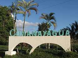
Cumanayagua
From Wikipedia, the free encyclopedia
| Cumanayagua | |
|---|---|
| Municipality | |
 | |
.png) Cienfuegos Province (yellow) and Cuba | |
 | |
| Coordinates: 22°09′8″N 80°12′4″W / 22.15222°N 80.20111°WCoordinates: 22°09′8″N 80°12′4″W / 22.15222°N 80.20111°W | |
| Country |
|
| Province | Cienfuegos |
| Established | 1976 |
| Area[1] | |
| • Total | 1,099 km2 (424 sq mi) |
| Elevation | 60 m (200 ft) |
| Population (2004)[2] | |
| • Total | 51,435 |
| • Density | 46.8/km2 (121/sq mi) |
| Time zone | EST (UTC-5) |
| Area code(s) | +53-432 |
Cumanayagua (Spanish pronunciation: [kumanaˈʝaɣwa]) is a municipality and city in the Cienfuegos Province of Cuba. It is located 23 kilometres (14 mi) east of Cienfuegos, the provincial capital.
Demographics
In 2004, the municipality of Cumanayagua had a population of 51,435.[2] With a total area of 1,099 km2 (424 sq mi),[1] it has a population density of 46.8 /km2 (121 /sq mi).
Economy
Citrics and coffee are grown in the municipality of Cumanayagua.
See also
References
- ↑ 1.0 1.1 Statoids (July 2003). "Municipios of Cuba". Retrieved 2007-10-07.
- ↑ 2.0 2.1 Atenas.cu (2004). "2004 Population trends, by Province and Municipality". Archived from the original on 2007-09-27. Retrieved 2007-10-07. (Spanish)
External links
![]() Media related to Cumanayagua at Wikimedia Commons
Media related to Cumanayagua at Wikimedia Commons
This article is issued from Wikipedia. The text is available under the Creative Commons Attribution/Share Alike; additional terms may apply for the media files.