Crap Masegn
From Wikipedia, the free encyclopedia
| Crap Masegn | |
|---|---|
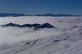
 Crap Masegn seen from north; peak to the right of the station called Crap Masegn. | |
| Elevation | 2,516 m (8,255 ft) |
| Prominence | 133 m (436 ft)[1] |
| Location | |
 Crap Masegn | |
| Location | Graubünden, Switzerland |
| Range | Glarus Alps |
| Coordinates | 46°51′01.3″N 9°10′16″E / 46.850361°N 9.17111°ECoordinates: 46°51′01.3″N 9°10′16″E / 46.850361°N 9.17111°E |
| Climbing | |
| Easiest route | Aerial tramway |
The Crap Masegn is a mountain of the Glarus Alps, located near Flims in the canton of Graubünden, Switzerland. It lies south of the Vorab.
Territorially it divides on the municipal areas of Falera on its eastern face, a narrow southern stripe of Ladir and Ruschein on its western face.
There is a station of an aerial cableway of the same name which is nowhere near this peak but one kilometer southeast, on the nameless junction of the two ridges of Crest Da Tiarms and Crest La Siala. There is a chairlift and a gondola lift ending there as well, all of them belonging to the skiing resort of Flims-Laax-Falera[2] which uses the name of Laax only for winter marketing.
References
- ↑ Retrieved from the Swisstopo topographic maps. The key col is the Fuorcla da Sagogn (2,383 m)
- ↑ Ski Switzerland Graubünden, Flims Laax
External links
This article is issued from Wikipedia. The text is available under the Creative Commons Attribution/Share Alike; additional terms may apply for the media files.