County of Bowen

From Wikipedia, the free encyclopedia
Bowen
Queensland

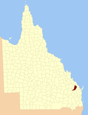
Location within Queensland
Lands administrative divisions around Bowen:
Yarrol Flinders Cook
Yarrol Bowen Cook
Wicklow Mackenzie Cook

The County of Bowen is a cadastral division in Queensland, Australia, located in the Wide Bay-Burnett region to the west of Bundaberg. It was named in honour of Sir George Ferguson Bowen, the first Governor of Queensland.[1][2] On 7 March 1901, the Governor issued a proclamation legally dividing Queensland into counties under the Land Act 1897.[3] Its schedule described Bowen thus:

Bounded on the east by the county of Cook; on the south by the county of Mackenzie; on the west by [...] the parishes of Mundowran, Boomerang, Binjour, Jonday, Yenda, Wolca, Wombah, Kolonga and Toweran; and on the north by the northern boundaries of the parishes of Toweran, Kolonga and Manduran.

Parishes

Bowen is divided into parishes, as listed below:

Parish LGA Coordinates Towns
Binjour North Burnett 25°33′S 151°29′E / 25.550°S 151.483°E / -25.550; 151.483 (Binjour Parish) Binjour
Boolbunda Bundaberg 25°03′S 151°42′E / 25.050°S 151.700°E / -25.050; 151.700 (Boolbunda Parish) Boolboonda
Chin Chin North Burnett 25°11′S 151°50′E / 25.183°S 151.833°E / -25.183; 151.833 (Chin Chin Parish)
Gin Gin Bundaberg 25°00′S 152°00′E / 25.000°S 152.000°E / -25.000; 152.000 (Gin Gin Parish) Gin Gin, Bullyard, Tirroan
Grosvenor North Burnett 25°14′S 151°41′E / 25.233°S 151.683°E / -25.233; 151.683 (Grosvenor Parish)
Joanborough Bundaberg 24°56′S 151°54′E / 24.933°S 151.900°E / -24.933; 151.900 (Joanborough Parish)
Jonday North Burnett 25°25′S 151°30′E / 25.417°S 151.500°E / -25.417; 151.500 (Jonday Parish)
Kolonga Bundaberg 24°51′S 151°43′E / 24.850°S 151.717°E / -24.850; 151.717 (Kolonga Parish) Kolonga
Mingo North Burnett 25°20′S 151°46′E / 25.333°S 151.767°E / -25.333; 151.767 (Mingo Parish)
Monduran Bundaberg 24°49′S 151°54′E / 24.817°S 151.900°E / -24.817; 151.900 (Monduran Parish) Monduran
Moolboolaman Bundaberg 25°01′S 151°49′E / 25.017°S 151.817°E / -25.017; 151.817 (Moolboolaman Parish) Moolboolaman
Mount Perry North Burnett 25°09′S 151°42′E / 25.150°S 151.700°E / -25.150; 151.700 (Mount Perry Parish) Mount Perry
St Agnes Bundaberg 25°16′S 151°57′E / 25.267°S 151.950°E / -25.267; 151.950 (St Agnes Parish)
Tarrara North Burnett 25°27′S 151°37′E / 25.450°S 151.617°E / -25.450; 151.617 (Tarrara Parish) Yenda
Taughboyne North Burnett 25°33′S 151°37′E / 25.550°S 151.617°E / -25.550; 151.617 (Taughboyne Parish) Gayndah (N), Ideraway
Toweran Gladstone 24°42′S 151°41′E / 24.700°S 151.683°E / -24.700; 151.683 (Toweran Parish)
Walla Bundaberg 25°06′S 151°56′E / 25.100°S 151.933°E / -25.100; 151.933 (Walla Parish) Wallaville
Wateranga North Burnett 25°23′S 151°50′E / 25.383°S 151.833°E / -25.383; 151.833 (Wateranga Parish)
Wetheron North Burnett 25°27′S 151°44′E / 25.450°S 151.733°E / -25.450; 151.733 (Wetheron Parish)
Wolca North Burnett 25°11′S 151°34′E / 25.183°S 151.567°E / -25.183; 151.567 (Wolca Parish)
Wonbah Bundaberg 25°01′S 151°37′E / 25.017°S 151.617°E / -25.017; 151.617 (Wonbah Parish)
Yenda North Burnett 25°20′S 151°38′E / 25.333°S 151.633°E / -25.333; 151.633 (Yenda Parish)

References

  1. Department of Environment and Resource Management. "Place name details — Bowen". Retrieved 4 June 2013. 
  2. Wide Bay/Burnett Districts, County of Bowen Maps - D2 Series at Queensland Archives.
  3. "A Proclamation". Queensland Government Gazette 75. 8 March 1901. pp. 967–980. 

Coordinates: 25°11′S 151°39′E / 25.183°S 151.650°E / -25.183; 151.650


This article is issued from Wikipedia. The text is available under the Creative Commons Attribution/Share Alike; additional terms may apply for the media files.