Couin
From Wikipedia, the free encyclopedia
| Couin | |
|---|---|
 | |
 Couin | |
|
Location within Nord-Pas-de-Calais region  Couin | |
| Coordinates: 50°07′50″N 2°33′09″E / 50.1306°N 2.5525°ECoordinates: 50°07′50″N 2°33′09″E / 50.1306°N 2.5525°E | |
| Country | France |
| Region | Nord-Pas-de-Calais |
| Department | Pas-de-Calais |
| Arrondissement | Arras |
| Canton | Pas-en-Artois |
| Intercommunality | Deux Sources |
| Government | |
| • Mayor (2008–2014) | Francis Savoye |
| Area | |
| • Land1 | 5.82 km2 (2.25 sq mi) |
| Population (1999) | |
| • Population2 | 90 |
| • Population2 Density | 15/km2 (40/sq mi) |
| INSEE/Postal code | 62242 / 62760 |
| Elevation |
90–159 m (295–522 ft) (avg. 135 m or 443 ft) |
|
1 French Land Register data, which excludes lakes, ponds, glaciers > 1 km² (0.386 sq mi or 247 acres) and river estuaries. 2 Population without double counting: residents of multiple communes (e.g., students and military personnel) only counted once. | |
Couin is a commune in the Pas-de-Calais department in the Nord-Pas-de-Calais region of France.
Geography
A small farming village located 16 miles (25 km) southwest of Arras at the junction of the D25 and D2 roads, by the banks of the Authie river.
Population
| Year | 1962 | 1968 | 1975 | 1982 | 1990 | 1999 |
|---|---|---|---|---|---|---|
| Population | 59 | 90 | 91 | 79 | 71 | 90 |
| From the year 1962 on: No double counting—residents of multiple communes (e.g. students and military personnel) are counted only once. | ||||||
Places of interest
- The church of St.Pierre, dating from the seventeenth century.
- The eighteenth-century chateau.
- Three Commonwealth War Graves Commission cemeteries.
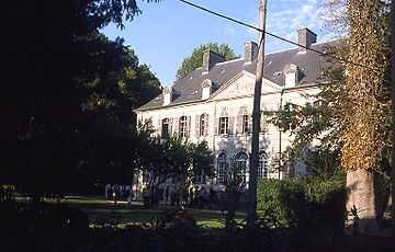
The chateau, built in 1748 by Philippe de Landas, Count of Louvignies

Part of the church
See also
References
External links
This article is issued from Wikipedia. The text is available under the Creative Commons Attribution/Share Alike; additional terms may apply for the media files.