Cotmanhay
From Wikipedia, the free encyclopedia
Coordinates: 52°58′58″N 1°18′31″W / 52.98278°N 1.3087°W
| Cotmanhay | |
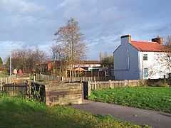
 Cotmanhay linear park |
|
 Cotmanhay | |
| District | Erewash |
|---|---|
| Shire county | Derbyshire |
| Region | East Midlands |
| Country | England |
| Sovereign state | United Kingdom |
| Postcode district | DE |
| Police | Derbyshire |
| Fire | Derbyshire |
| Ambulance | East Midlands |
| EU Parliament | East Midlands |
| UK Parliament | Erewash |
| |
Cotmanhay is a village in Derbyshire, England, UK, in the Erewash Borough Council area, north of Ilkeston.
The neighbourhood's two main industries were textiles and coal mining, the latter from 1848 until 1880.
References
External links
| Wikimedia Commons has media related to Cotmanhay. |
See also
This article is issued from Wikipedia. The text is available under the Creative Commons Attribution/Share Alike; additional terms may apply for the media files.