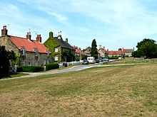
Coneysthorpe
From Wikipedia, the free encyclopedia
Coordinates: 54°07′57″N 0°54′42″W / 54.13251°N 0.91177°W

| Coneysthorpe | |
 Coneysthorpe | |
| OS grid reference | SE712712 |
|---|---|
| Civil parish | Coneysthorpe |
| District | Ryedale |
| Shire county | North Yorkshire |
| Region | Yorkshire and the Humber |
| Country | England |
| Sovereign state | United Kingdom |
| Post town | YORK |
| Postcode district | YO60 |
| Police | North Yorkshire |
| Fire | North Yorkshire |
| Ambulance | Yorkshire |
| EU Parliament | Yorkshire and the Humber |
| UK Parliament | Thirsk and Malton (formerly Ryedale) |
Coneysthorpe is a small village and civil parish in the Ryedale district of North Yorkshire, England. It is situated near Castle Howard and 4 miles west of Malton. The Centenary Way long-distance path runs through the village.

Coneysthorpe
External links
![]() Media related to Coneysthorpe at Wikimedia Commons
Media related to Coneysthorpe at Wikimedia Commons
This article is issued from Wikipedia. The text is available under the Creative Commons Attribution/Share Alike; additional terms may apply for the media files.