Conceição do Almeida
From Wikipedia, the free encyclopedia
| Conceição do Almeida | |
|---|---|
 | |
| Coordinates: 12°37′4″S 39°57′21″W / 12.61778°S 39.95583°WCoordinates: 12°37′4″S 39°57′21″W / 12.61778°S 39.95583°W | |
| Country |
|
| Region | Northeast |
| State | Bahia |
| Area | |
| • Total | 398.472 km2 (153.851 sq mi) |
| Population (2006) | |
| • Total | 31,966 |
| • Density | 80.22/km2 (207.8/sq mi) |
| Time zone | UTC-3 (UTC-3) |
| • Summer (DST) | UTC-2 (UTC-2) |
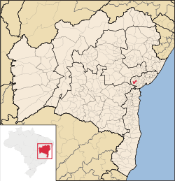
Conceição do Almeida is a Brazilian municipality in the state of Bahia. Its estimated population as of 2006 was 31,966 inhabitants.
Conceição do Almeida was organized in 18 July 1890, Its territory used to belong to São Felipe.
The anthem was written by the poet Castro Alves.
This article is issued from Wikipedia. The text is available under the Creative Commons Attribution/Share Alike; additional terms may apply for the media files.
