Comancheria

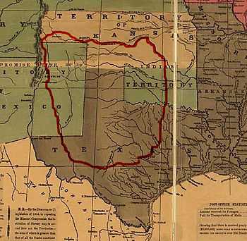
The Comancheria or Nʉmʉnʉʉ Sookobitʉ ("Comanche Earth") in Comanche (Nʉmʉ Tekwapʉ) is the name commonly given to the region of New Mexico, west Texas and nearby areas occupied by the Comanche before the 1860s.
Geography
The area was vaguely defined and shifted over time, but generally was described as bordered to the south by the Balcones Fault, just north of San Antonio, Texas, continuing north along the Cross Timbers to encompass a northern area that included the Cimarron River and the upper Arkansas River east of the high Rockies. Comancheria was bordered along the west by the Mescalero Escarpment and the Pecos River, continuing north along the edge of the Spanish settlements in Santa Fe de Nuevo México.[1]
Apachería
Before the Comanche expanded out of present day Wyoming in the early eighteenth century, the lands now known as Comacheria was home to a multitude of tribes—most notably the Apaches. Much of the region had previously been known as Apachería.[2]
Comancheria as empire
Pekka Hämäläinen (2008) argues that from the 1750s to the 1850s, the Comanches were the dominant group in the Southwest, and the domain they ruled was known as Comancheria. Hämäläinen calls it an empire. Confronted with Spanish, Mexican, and American outposts on their periphery in New Mexico, Texas, Louisiana, and Mexico, they worked to increase their own safety, prosperity and power. The Comanches used their military power to obtain supplies and labor from the Americans, Mexicans, and Indians through thievery, tribute, and kidnappings. (See Comanche-Mexico War) Although powered by violence, the Comanche empire was primarily an economic construction, rooted in an extensive commercial network that facilitated long-distance trade. Dealing with subordinate Indians, the Comanche spread their language and culture across the region. Their empire collapsed when their villages were repeatedly decimated by epidemics of smallpox and cholera in the late 1840s; the population plunged from 20,000 to just a few thousand by the 1870s.[3]
Neighboring peoples
In the west, southwest and southeast of the Comanchería stretched the vast territories of the various hostile Apache groups, partially overlapping and forming a kind of no man's land, which was heavily contested between the two peoples. Moreover, the Comanche had to pass through the dangerous Apachería on their way down to Mexico for raiding and recross it with plunder. The Oklahoma and Texas Panhandle were inhabited by their allies, the Kiowa and Kiowa-Apache, along with the Comanche. In the northwest of the Comancheria lived the opposing Ute and Shoshone, to the northeast settled the enemy and powerful Osage and in the north the also antagonistic Pawnee. In addition, in and adjacent to the Comanchería settled the allied Wichita, Tawakoni, Waco (Spanish: Hueco, were a subtribe of the Wichita) and Hasinai. In the East lived the Caddo and later the Cherokee. In the southeast settled the erstwhile allies, but after the expulsion of the Apaches of the Plains, now rival Tonkawa. In the north, the Southern Cheyenne and Southern Arapaho, forced the Comanche to acknowledge the Arkansas River as their northern border. Moreover, the Comanche undertook extensive commercial enterprises to the Pueblo in New Mexico and to the Spanish settlements around San Antonio, Texas. In this illegal trade of guns, horses, captives and other goods the Comancheros (Pueblo and New Mexico traders) acted as intermediaries. The Ciboleros also competed against the Comanche in the context of bison hunting. The Comanche language became the Lingua franca of the Southern Plains.
Geographic information
Today, this region makes up West Texas, the Llano Estacado, the Texas Panhandle, the Edwards Plateau (including the Texas Hill Country), Eastern New Mexico, the Oklahoma Panhandle, the Wichita Mountains, and half portions of Colorado and Kansas.[citation needed]
See also
References
Hämäläinen, Pekka (2008). The Comanche Empire. Yale University Press. ISBN 978-0-300-12654-9.