Coed-Ely
From Wikipedia, the free encyclopedia
Coordinates: 51°33′58″N 3°25′01″W / 51.566°N 3.417°W
| Coed-Ely | |
| Welsh: Coed-Elái | |
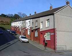
 Garth Street, Coed-Ely |
|
 Coed-Ely | |
| Principal area | Rhondda Cynon Taf |
|---|---|
| Ceremonial county | Mid Glamorgan |
| Country | Wales |
| Sovereign state | United Kingdom |
| Police | South Wales |
| Fire | South Wales |
| Ambulance | Welsh |
| EU Parliament | Wales |
| UK Parliament | Pontypridd |
| |
Coed-Ely is a small village located to the south of Tonyrefail in south Wales and is located in the County Borough of Rhondda Cynon Taf. The name Coed-Ely is a derivative of the Welsh words Coed-Elái which can be loosely translated into English as Ely Woods.
This article is issued from Wikipedia. The text is available under the Creative Commons Attribution/Share Alike; additional terms may apply for the media files.
