Clinton, New Jersey
| Clinton, New Jersey | |
|---|---|
| Town | |
| Town of Clinton | |
 | |
 | |
 | |
| Coordinates: 40°38′13″N 74°54′55″W / 40.63681°N 74.915205°WCoordinates: 40°38′13″N 74°54′55″W / 40.63681°N 74.915205°W[1][2] | |
| Country | United States |
| State | New Jersey |
| County | Hunterdon |
| Incorporated | April 5, 1865 |
| Named for | DeWitt Clinton |
| Government[3] | |
| • Type | Town |
| • Mayor | Janice Kovach (term ends December 31, 2015)[4] |
| • Clerk | Cecilia Covino[5] |
| Area[2] | |
| • Total | 1.417 sq mi (3.670 km2) |
| • Land | 1.338 sq mi (3.465 km2) |
| • Water | 0.079 sq mi (0.205 km2) 5.59% |
| Area rank |
459th of 566 in state 18th of 26 in county[2] |
| Elevation[6] | 194 ft (59 m) |
| Population (2010 Census)[7][8][9] | |
| • Total | 2,719 |
| • Estimate (2012[10]) | 2,669 |
| • Rank |
459th of 566 in state 18th of 26 in county[11] |
| • Density | 2,032.6/sq mi (784.8/km2) |
| • Density rank |
290th of 566 in state 3rd of 26 in county[11] |
| Time zone | Eastern (EST) (UTC-5) |
| • Summer (DST) | Eastern (EDT) (UTC-4) |
| ZIP code | 08809[12][13] |
| Area code(s) | 908 Exchanges: 238,328,713,730,735 |
| FIPS code | 3401913720[14][2][15] |
| GNIS feature ID | 0885189[16][2] |
| Website | www.clintonnj.gov |
Clinton is a town in Hunterdon County, New Jersey, United States, located on the South Branch of the Raritan River. As of the 2010 United States Census, the town's population was 2,719,[7][8][9] reflecting an increase of 87 (+3.3%) from the 2,632 counted in the 2000 Census, which had in turn increased by 578 (+28.1%) from the 2,054 counted in the 1990 Census.[17]
When the Clinton post office was established in 1829, it was named for DeWitt Clinton, Governor of New York and the primary impetus behind the then-newly completed Erie Canal.[18]
Clinton was incorporated as a town by an Act of the New Jersey Legislature on April 5, 1865, within portions of Clinton, Franklin and Union Townships. Clinton gained full independence from its three parent townships in 1895.[19]
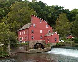
The town is perhaps best known for its two mills which sit on opposite banks of the South Branch Raritan River. The Red Mill, with its historic village, dates back to 1810 with the development of a mill for wool processing.[20] Across the river sits the Stone Mill, home of the Hunterdon Art Museum for Contemporary Craft and Design, located in a former gristmill that had been reconstructed in 1836 and operated continuously until 1952, when a group of local residents conceived of a plan to convert the historic building into a museum.[21]
Demographics
| Historical population | |||
|---|---|---|---|
| Census | Pop. | %± | |
| 1870 | 785 | ||
| 1880 | 842 | 7.3% | |
| 1890 | 913 | 8.4% | |
| 1900 | 816 | −10.6% | |
| 1910 | 836 | 2.5% | |
| 1920 | 950 | 13.6% | |
| 1930 | 932 | −1.9% | |
| 1940 | 1,066 | 14.4% | |
| 1950 | 1,118 | 4.9% | |
| 1960 | 1,158 | 3.6% | |
| 1970 | 1,742 | 50.4% | |
| 1980 | 1,910 | 9.6% | |
| 1990 | 2,054 | 7.5% | |
| 2000 | 2,632 | 28.1% | |
| 2010 | 2,719 | 3.3% | |
| Est. 2012 | 2,669 | [10] | −1.8% |
| Population sources: 1870-1920[22] 1870[23][24] 1880-1890[25] 1890-1910[26] 1910-1930[27] 1930-1990[28] 2000[29][30] 2010[7][8][9] | |||
Census 2010
At the 2010 United States Census, there were 2,719 people, 1,057 households, and 727.2 families residing in the town. The population density was 2,032.6 per square mile (784.8 /km2). There were 1,098 housing units at an average density of 820.8 per square mile (316.9 /km2). The racial makeup of the town was 89.52% (2,434) White, 1.32% (36) Black or African American, 0.22% (6) Native American, 6.66% (181) Asian, 0.00% (0) Pacific Islander, 0.63% (17) from other races, and 1.66% (45) from two or more races. Hispanic or Latino of any race were 6.22% (169) of the population.[7]
There were 1,057 households of which 37.0% had children under the age of 18 living with them, 55.2% were married couples living together, 9.7% had a female householder with no husband present, and 31.2% were non-families. 25.4% of all households were made up of individuals and 8.8% had someone living alone who was 65 years of age or older. The average household size was 2.57 and the average family size was 3.14.[7]
In the town, 26.0% of the population were under the age of 18, 6.1% from 18 to 24, 27.6% from 25 to 44, 28.8% from 45 to 64, and 11.5% who were 65 years of age or older. The median age was 39.6 years. For every 100 females there were 94.8 males. For every 100 females age 18 and over, there were 92.8 males.[7]
The Census Bureau's 2006-2010 American Community Survey showed that (in 2010 inflation-adjusted dollars) median household income was $83,850 (with a margin of error of +/- $12,019) and the median family income was $109,375 (+/- $19,698). Males had a median income of $62,697 (+/- $9,258) versus $67,014 (+/- $13,316) for females. The per capita income for the borough was $43,354 (+/- $4,395). About 2.6% of families and 3.2% of the population were below the poverty line, including 2.0% of those under age 18 and 11.9% of those age 65 or over.[31]
Census 2000
As of the 2000 United States Census[14] there were 2,632 people, 1,068 households, and 724 families residing in the town. The population density was 1,916.0 people per square mile (741.8/km2). There were 1,095 housing units at an average density of 797.1 per square mile (308.6/km2). The racial makeup of the town was 92.06% White, 1.33% African American, 0.46% Native American, 3.72% Asian, 1.37% from other races, and 1.06% from two or more races. Hispanic or Latino of any race were 4.10% of the population.[29][30]
There were 1,068 households out of which 35.4% had children under the age of 18 living with them, 55.3% were married couples living together, 8.9% had a female householder with no husband present, and 32.2% were non-families. 26.3% of all households were made up of individuals and 7.1% had someone living alone who was 65 years of age or older. The average household size was 2.46 and the average family size was 3.00.[29][30]
In the town the population was spread out with 26.4% under the age of 18, 4.7% from 18 to 24, 35.4% from 25 to 44, 24.2% from 45 to 64, and 9.4% who were 65 years of age or older. The median age was 37 years. For every 100 females there were 95.3 males. For every 100 females age 18 and over, there were 92.3 males.[29][30]
The median income for a household in the town was $78,121, and the median income for a family was $88,671. Males had a median income of $61,442 versus $46,397 for females. The per capita income for the town was $37,463. About 0.4% of families and 2.8% of the population were below the poverty line, including 0.6% of those under age 18 and 1.6% of those age 65 or over.[29][30]
Transportation
The Town of Clinton is situated off Route 31, which is in turn off of Interstate 78/U.S. Route 22 via Exits 16 and 17. Route 173 and County Road 513 run through the center of town. Convenient access to Interstate 78 provides Clinton with a convenient route to and from New York City and the Lehigh Valley in Pennsylvania. Philadelphia can also be easily accessed from Clinton via NJ Route 31 to Interstate 95 South.
Public transportation is very limited. The LINK, which serves Hunterdon County is the only traditional, publically funded mode of transportation. Fares range from about $2.00 to $10.00. Funding for operation of the Hunterdon County LINK System is provided by Hunterdon County, New Jersey Transit and the Federal Transit Administration.[32]
Trans-Bridge Lines offers buses on a route that provides service from Allentown and Bethlehem, Pennsylvania to the Port Authority Bus Terminal in Midtown Manhattan and New York City-area airports at a stop at the park-and-ride on Route 31 in Clinton.[33] Limited NJ Transit Rail is also accessible at the Annandale station on the Raritan Valley Line.[34][35]
Geography
Clinton is located at 40°38′13″N 74°54′55″W / 40.63681°N 74.915205°W (40.63681,-74.915205). According to the United States Census Bureau, the town had a total area of 1.417 square miles (3.670 km2), of which, 1.338 square miles (3.465 km2) of it is land and 0.079 square miles (0.205 km2) of it (5.59%) is water.[1][2]
The town borders Clinton Township, Franklin Township, and Union Township.
Clinton is considered an exurb of New York City, as Hunterdon County lies on the western fringe of the New York City Metropolitan Area, which is mainly rural with scattered housing developments and old farm homes. Clinton is part of the Primary Metropolitan Statistical Area of Middlesex, Somerset and Hunterdon counties in New Jersey.[36] It serves as a "bedroom community" for many commuters working in and around Northern New Jersey and New York City, often younger residents who have supplanted long-time residents of Clinton.[37]
Climate
| Climate data for Clinton, New Jersey | |||||||||||||
|---|---|---|---|---|---|---|---|---|---|---|---|---|---|
| Month | Jan | Feb | Mar | Apr | May | Jun | Jul | Aug | Sep | Oct | Nov | Dec | Year |
| Average high °F (°C) | 36.8 (2.7) |
39.9 (4.4) |
49.8 (9.9) |
61.3 (16.3) |
72.0 (22.2) |
80.2 (26.8) |
85.1 (29.5) |
83.1 (28.4) |
75.6 (24.2) |
64.4 (18) |
52.8 (11.6) |
41.6 (5.3) |
61.9 (16.6) |
| Average low °F (°C) | 18.4 (−7.6) |
20.0 (−6.7) |
28.1 (−2.2) |
37.0 (2.8) |
46.9 (8.3) |
56.0 (13.3) |
61.7 (16.5) |
59.9 (15.5) |
52.0 (11.1) |
40.0 (4.4) |
32.2 (0.1) |
24.0 (−4.4) |
39.7 (4.3) |
| Source: <Flemington 5 NNW Weather Station= >FLEMINGTON 5 NNW Weather station (2009). "Clinton, NJ Weather". Clinton, NJ Weather Data. Open Publishing. Retrieved 1 December 2009. | |||||||||||||
Clinton falls under the 'Northern New Jersey' climate zone. According to the Office of the New Jersey State Climatologist at Rutgers University, the Northern climate zone covers about one-quarter of New Jersey and consists mainly of elevated highlands and valleys which are part of the Appalachian Uplands. Surrounded by land, this region can be characterized as having a continental climate with minimal influence from the Atlantic Ocean, except when the winds contain an easterly component. Prevailing winds are from the southwest in summer and from the northwest in winter. Being in the northernmost portion of the state, and with small mountains up to 1,800 feet (550 m) in elevation, the Northern Zone normally exhibits a colder temperature regime than other climate regions of the State of New Jersey. This difference is most dramatic in winter when average temperatures in the Northern Zone can be more than ten degrees Fahrenheit cooler than in the Coastal Zone. Annual snowfall averages 40 to 50 inches (1,300 mm) in the northern zone as compared with an average of 10-15 inches in the extreme south.[38]
Government
Local government
Clinton is governed under the Town form of government with a mayor and a six-member Town Council. The Mayor is directly elected by the voters to a four-year term of office. Members of the Town Council are elected to three-year terms of office on a staggered basis, with two seats coming up for election each year.[3] The primary responsibilities of the Council are to serve as the legislative body of the town, approve the annual budget presented by the Mayor, approve payment of bills and serve as Liaisons to several Boards and Committees.
As of 2013, the mayor of Clinton Town is Democrat Janice Kovach, whose term of office ends on December 31, 2015.[39][40] Members of the Clinton Town Council are Ken Carberry (R, 2014; elected in 2012 to an unexpired two-year term), Al Rylak (November 2013; appointed in September 2013 to fill the vacancy of Megan Jones-Holt, who in turn had been appointed in February 2013 to fill the vacancy of Rich Duffy), Marty Pendergast (2014), Daniel Shea (R, 2015), Robert Smith (R, 2013) and Beth Sosidka (R, 2015).[18][41][42][43][44]
Fire department
Clinton Fire Department (CFD) is located on the corner of New Street / Old Route 22 in Clinton. About 15% of the department's calls annually involve actual fire, while the rest of the CFD's calls are roughly broken down to 15% motor vehicle accidents, 15% hazardous conditions, 5% service calls, 25% good intent calls with no fire found and 25% alarm activations/false alarms, averaging about 190 calls annually.[45] The department offers three types of membership namely Active firefighter, Junior firefighter and Associate membership to prospective members. The department runs mutual aid calls with Annandale Hose Company, High Bridge Fire Department, Quakertown Fire Company, Lebanon Fire Company and Pattenburg Fire Company and other fire departments in Hunterdon Country, which have become an invaluable resource for large incidents.[46]
Federal, state and county representation
Clinton Town is located in the 7th Congressional District[47] and is part of New Jersey's 23rd state legislative district.[8][48][49]
New Jersey's Seventh Congressional District is represented by Leonard Lance (R, Clinton Township).[50] New Jersey is represented in the United States Senate by Cory Booker (D, Newark; took office on October 31, 2013, after winning a special election to fill the seat of Frank Lautenberg)[51][52] and Bob Menendez (D, North Bergen).[53][54]
For the 2014-2015 Session, the 23rd Legislative District of the New Jersey Legislature is represented in the State Senate by Michael J. Doherty (R, Washington Township, Warren County) and in the General Assembly by John DiMaio (R, Hackettstown) and Erik Peterson (R, Franklin Township, Hunterdon County).[55][56] The Governor of New Jersey is Chris Christie (R, Mendham Township).[57] The Lieutenant Governor of New Jersey is Kim Guadagno (R, Monmouth Beach).[58]
Hunterdon County is governed by a five-member Board of Chosen Freeholders, who serve three-year terms of office at-large on a staggered basis, with either one or two seats up for election each year. At an annual reorganization meeting held each January, the freeholders select one member to serve as the board's Director and another to serve as Deputy Director.[59] As of 2013, Hunterdon County's Freeholders are Freeholder Director Robert G. Walton (Hampton, 2014),[60] Freeholder Deputy Director J. Matthew Holt (Clinton Town, 2015),[61] John King (Raritan Township, 2015), George B. Melick (Tewksbury Township, 2013)[62] and William G. Mennen (Tewksbury Township, 2013).[63].[64] Constitutional officers elected on a countywide basis are County Clerk Mary H. Melfi (Flemington, 2014),[65] Sheriff Fredrick W. Brown (Alexandria Township, 2013)[66] Surrogate Susan J. Hoffman (Kingwood Township, 2013).[67][68]
Politics
As of March 23, 2011, there were a total of 1,671 registered voters in Clinton, of which 439 (26.3%) were registered as Democrats, 529 (31.7%) were registered as Republicans and 700 (41.9%) were registered as Unaffiliated. There were 3 voters registered to other parties.[69]
In the 2008 presidential election, Democrat Barack Obama received 49.4% of the vote here (704 cast), ahead of Republican John McCain with 48.7% (694 votes) and other candidates with 1.2% (17 votes), among the 1,426 ballots cast by the town's 1,732 registered voters, for a turnout of 82.3%.[70] In the 2004 presidential election, Republican George W. Bush received 54.8% of the vote here (761 ballots cast), outpolling Democrat John Kerry with 44.0% (611 votes) and other candidates with 0.7% (12 votes), among the 1,389 ballots cast by the town's 1,671 registered voters, for a turnout percentage of 83.1.[71]
In the 2009 gubernatorial election, Republican Chris Christie received 60.5% of the vote here (620 ballots cast), ahead of Democrat Jon Corzine with 27.7% (284 votes), Independent Chris Daggett with 9.5% (97 votes) and other candidates with 0.7% (7 votes), among the 1,025 ballots cast by the town's 1,711 registered voters, yielding a 59.9% turnout.[72]
Education
Clinton-Glen Gardner School District is school district based in the Town of Clinton, that serves students from Clinton Town and Glen Gardner Borough in Pre-Kindergarten through eighth grade at Clinton Public School. Before Glen Gardner, a non-operating district, was consolidated into the district, students from the borough had attend the district's school as part of a sending/receiving relationship. Other students attend the school on a tuition basis.[73] Formerly known as the Town of Clinton School District, the district's board of education voted in November 2009 to revise the name to Clinton-Glen Gardner School District to reflect the merger.[74] As of the 2010-11 school year, the school had an enrollment of 507 students.[75]
Students in public school for ninth through twelfth grades attend North Hunterdon High School in Annandale as part of the North Hunterdon-Voorhees Regional High School District. North Hunterdon High School serves Clinton, as well as students from Bethlehem Township, Clinton Township, Franklin Township, Lebanon Borough and Union Township.[76]
Economy
The construction company Foster Wheeler has its operational headquarters in Clinton.[77]
Tourism and points of interest
- The Red Mill is located on the South Branch of the Raritan River in the town center of Clinton. Built in 1810, the Red Mill originally served as a woolen mill. Over the next 100 years, the Mill was used at different times to process grains, plaster, talc and graphite. The Mill was also used to produce peach baskets, as well as to generate electricity and pump water for the town. Every October, The mill is transformed into a haunted house given the title, the Haunted Mill. The Haunted Mill tends to attract visitors from all over the east coast to the small town. The Red Mill was featured on an episode of Ghost Hunters in 2008.[78]
- The Hunterdon Art Museum (7 Lower Center Street) is located in a mill established in 1836, and offers exhibitions of contemporary art, craft and design, docent tours and over 200 education programs for adults and children.[21]
- Landsdown Trail, a spur line constructed for the Lehigh Valley Railroad in 1881 that is now a graded rail trail starting about 2 miles (3.2 km) south of Clinton on Landsdown Road that enters Clinton town center near the lumber yard.[79]
- Spruce Run Recreation Area (Van Syckel’s Road, Clinton, NJ): 1,961 acres (7.94 km2), picnicking, boating, fishing and seasonal camping. Open year-round.[80]
- Round Valley Recreation Area (Lebanon-Stanton Road, Lebanon, NJ) offers wilderness camping, beaches, trails, fishing and boating.[81]
Popular culture references
- The town was featured on The Daily Show, which interviewed a local resident who was campaigning to have the town's name changed to Reagan after the Republican President of the United States Ronald Reagan, during the Clinton Administration.[citation needed]
- Several movies have used the town as a backdrop, including In and Out with Kevin Kline, One True Thing with Renée Zellweger and Meryl Streep, My Giant with Billy Crystal, and Turbulence with Ray Liotta.
- The CBS-TV daytime drama As The World Turns taped scenes at businesses along Main Street in 2008 and 2009.[82]
Notable people
Notable current and former residents of Clinton include:
- John T. Bird (1829–1911), represented New Jersey's 3rd congressional district from 1869 to 1873.[83]
- James Valenti (born 1977), operatic tenor.[84]
- Foster McGowan Voorhees (1856-1927), Governor of New Jersey from 1899 to 1902.[85]
- Anna Case (1888 – 1984), American Soprano who recorded with Thomas Edison.
Gallery
| Wikimedia Commons has media related to Clinton, New Jersey. |
-
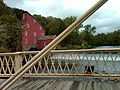
Main Street Bridge in Clinton, NJ looking at Red Mill
-

Raritan river running through Clinton, New Jersey
-

Bridge of Clinton, NJ
-

Main Street of Clinton, New Jersey
-

Shops fronts along Main Street, Clinton, NJ
-

Library of Clinton, NJ
-

Clinton House Restaurant
-
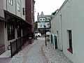
Alley in Clinton, NJ
-

Tall building on Main Street in Clinton, NJ
References
- ↑ 1.0 1.1 "US Gazetteer files: 2010, 2000, and 1990". United States Census Bureau. 2011-02-12. Retrieved 2011-04-23.
- ↑ 2.0 2.1 2.2 2.3 2.4 2.5 Gazetteer of New Jersey Places, United States Census Bureau. Accessed June 14, 2013.
- ↑ 3.0 3.1 2012 New Jersey Legislative District Data Book, Rutgers University Edward J. Bloustein School of Planning and Public Policy, March 2013, p. 103.
- ↑ 2013 New Jersey Mayors Directory, New Jersey Department of Community Affairs. Accessed May 12, 2013.
- ↑ Town Clerk, Town of Clinton. Accessed November 14, 2012.
- ↑ U.S. Geological Survey Geographic Names Information System: Town of Clinton, Geographic Names Information System. Accessed March 5, 2013.
- ↑ 7.0 7.1 7.2 7.3 7.4 7.5 DP-1 - Profile of General Population and Housing Characteristics: 2010 for Clinton town, Hunterdon County, New Jersey, United States Census Bureau. Accessed November 14, 2012.
- ↑ 8.0 8.1 8.2 8.3 Municipalities Grouped by 2011-2020 Legislative Districts, New Jersey Department of State, p. 10. Accessed January 6, 2013.
- ↑ 9.0 9.1 9.2 Profile of General Demographic Characteristics: 2010 for Clinton town, New Jersey Department of Labor and Workforce Development. Accessed November 14, 2012.
- ↑ 10.0 10.1 PEPANNRES - Annual Estimates of the Resident Population: April 1, 2010 to July 1, 2012 - 2012 Population Estimates for New Jersey municipalities, United States Census Bureau. Accessed July 7, 2013.
- ↑ 11.0 11.1 GCT-PH1 Population, Housing Units, Area, and Density: 2010 - State -- County Subdivision from the 2010 Census Summary File 1 for New Jersey, United States Census Bureau. Accessed November 14, 2012.
- ↑ Look Up a ZIP Code for Clinton, NJ, United States Postal Service. Accessed November 14, 2012.
- ↑ Zip Codes, State of New Jersey. Accessed September 2, 2013.
- ↑ 14.0 14.1 "American FactFinder". United States Census Bureau. Retrieved 2008-01-31.
- ↑ A Cure for the Common Codes: New Jersey, Missouri Census Data Center. Accessed October 27, 2012.
- ↑ "US Board on Geographic Names". United States Geological Survey. 2007-10-25. Retrieved 2008-01-31.
- ↑ Table 7. Population for the Counties and Municipalities in New Jersey: 1990, 2000 and 2010, New Jersey Department of Labor and Workforce Development, February 2011. Accessed November 14, 2012.
- ↑ 18.0 18.1 The Town of Clinton. Hunterdon County, New Jersey. Accessed September 14, 2013.
- ↑ Snyder, John P. The Story of New Jersey's Civil Boundaries: 1606-1968, Bureau of Geology and Topography; Trenton, New Jersey; 1969. p. 154. Accessed October 25, 2012.
- ↑ The Red Mill: A Spin of the Wheel, The Red Mill Museum. Accessed July 21, 2011.
- ↑ 21.0 21.1 About the Museum, Hunterdon Art Museum. Accessed July 21, 2011.
- ↑ Compendium of censuses 1726-1905: together with the tabulated returns of 1905, New Jersey Department of State, 1906. Accessed October 8, 2013.
- ↑ Raum, John O. The History of New Jersey: From Its Earliest Settlement to the Present Time, Volume 1, p. 266, J. E. Potter and company, 1877. Accessed October 8, 2013. "Clinton township was formed from Lebanon in 1838. Its population in 1850 was 2,369; in 1860 including the village of Clinton 2,949; and in 1870, 3,134. This village was formerly called Hunt's Mills, from an early proprietor, in consequence of its valuable water power. It is beautifully diversified with hills, was incorporated as a borough in 1865, and contained in 1870, 785 inhabitants."
- ↑ Staff. A compendium of the ninth census, 1870, p. 259. United States Census Bureau, 1872. Accessed October 8, 2013.
- ↑ Porter, Robert Percival. Preliminary Results as Contained in the Eleventh Census Bulletins: Volume III - 51 to 75, p. 98. United States Census Bureau, 1890. Accessed November 13, 2012.
- ↑ Thirteenth Census of the United States, 1910: Population by Counties and Minor Civil Divisions, 1910, 1900, 1890, United States Census Bureau, p. 337. Accessed November 13, 2012.
- ↑ Fifteenth Census of the United States : 1930 - Population Volume I, United States Census Bureau, p. 716. Accessed November 13, 2012.
- ↑ New Jersey Resident Population by Municipality: 1930 - 1990, Workforce New Jersey Public Information Network, backed up by the Internet Archive as of May 2, 2009. Accessed November 13, 2012.
- ↑ 29.0 29.1 29.2 29.3 29.4 Census 2000 Profiles of Demographic / Social / Economic / Housing Characteristics for Clinton town, New Jersey, United States Census Bureau. Accessed November 14, 2012.
- ↑ 30.0 30.1 30.2 30.3 30.4 DP-1: Profile of General Demographic Characteristics: 2000 - Census 2000 Summary File 1 (SF 1) 100-Percent Data for Clinton town, Hunterdon County, New Jersey, United States Census Bureau. Accessed November 14, 2012.
- ↑ DP03: Selected Economic Characteristics from the 2006-2010 American Community Survey 5-Year Estimates for Clinton town, Hunterdon County, New Jersey, United States Census Bureau. Accessed November 14, 2012.
- ↑ LINK Hunterdon County Transportation, Hunterdon County Transportation. Accessed December 1, 2009.
- ↑ Schedule From Allentown/Easton/NJ to New York, Trans-Bridge Lines. Accessed July 21, 2011.
- ↑ Hunterdon County Bus/Rail Connections, New Jersey Transit, backed up by the Internet Archive as of May 22, 2009. Accessed July 21, 2011.
- ↑ Raritan Valley Line, New Jersey Transit. Accessed October 8, 2013.
- ↑ METROPOLITAN AREAS AND COMPONENTS, 1999, WITH FIPS CODES, United States Census Bureau. Accessed November 14, 2012.
- ↑ Sclafani, Tony. "11:15 A.M.", Courier News, June 26, 2001. Accessed July 21, 2011. "Godown, 61, who just returned from a breakfast with Hunterdon County's police chiefs in Clinton, parks his cruiser beside the police department's door and steps inside the tiny, sparklingly clean headquarters.... It's very quiet Godown says about the borough where he's been chief for more than a decade He says many older residents have gone and been replaced by younger adults turning the 1squaremile town into more of a bedroom community."
- ↑ ONJSC, Rutgers University. Accessed December 1, 2009.
- ↑ Mayor, Town of Clinton. Accessed September 2, 2013.
- ↑ Kiriluk-Hill, Renée. "New Clinton Mayor Janice Kovach is sworn in by state Sen. Barbara Buono", Hunterdon County Democrat, January 4, 2012. Accessed September 14, 2013. "Janice Kovach, a Democrat, was sworn in to a four-year term as mayor at a standing-room-only Town Council reorganization meeting on Monday, Jan. 2."
- ↑ Town Council, Town of Clinton. Accessed October 20, 2013.
- ↑ O'Brien, Walter. "Clinton Town swears in two councilmen; appoints professionals", Asbury Park Press, January 6, 2011. Accessed March 13, 2011. "Incumbent Republican Councilman Richard Duffy and Republican Robert Smith, returning to council for the first time since 2003, were sworn in Tuesday to the six-member town council for three-year terms. Duffy first joined the council in March 2008 replacing John Harrison, who passed away in February 2008. Former Councilman Todd Pender did not run for re-election."
- ↑ Staff. "Republicans win big in Clinton, High Bridge, Clinton Township", Hunterdon Review, November 6, 2012. Accessed September 14, 2013. "In Clinton, the Republicans won across the board for three open seats on Town Council. Republican and first-time candidate Ken Carberry won out over incumbent Democrat Brad Cohen for an unexpired two-year term, 52 percent to 48 percent. Republican Councilman Daniel Shea and first-time candidate and Republican Beth Sosidka garnered the two open three-year seats on council over former Interim Mayor and Democrat Richard Miller and first-time-candidate and Democrat Debra Schaffer."
- ↑ Kiriluk-Hill, Renée. "Jones-Holt appointed to Clinton Town Council", Hunterdon County Democrat, February 11, 2013. Accessed September 14, 2013. "Megan Jones-Holt, a businesswoman, active volunteer and wife of Freeholder Matt Holt, has been appointed to Town Council. She fills a vacancy created by the resignation last month of Rich Duffy, who moved to Connecticut because of a job transfer."
- ↑ Home page, Clinton Fire Department. Accessed July 21, 2011.
- ↑ Mutual Aid, Clinton Fire Department. Accessed July 21, 2011.
- ↑ Plan Components Report, New Jersey Redistricting Commission, December 23, 2011. Accessed January 6, 2013.
- ↑ 2012 New Jersey Citizen's Guide to Government, p. 56, New Jersey League of Women Voters. Accessed January 6, 2013.
- ↑ Districts by Number for 2011-2020, New Jersey Legislature. Accessed January 6, 2013.
- ↑ Directory of Representatives: New Jersey, United States House of Representatives. Accessed January 5, 2012.
- ↑ Cory A. Booker, United States Senate. Accessed November 5, 2013.
- ↑ via Associated Press. "Booker is officially a U.S. senator after being sworn in", NJ.com, October 31, 2013. Accessed October 31, 2013. "Former Newark Mayor Cory Booker was sworn in as a Democratic senator from New Jersey today, taking the oath of office, exchanging hugs with Vice President Joe Biden and acknowledging the applause of friends and family members seated in the visitor's gallery that rings the chamber.... Booker, 44, was elected to fill out the term of the late Sen. Frank Lautenberg, who died earlier this year."
- ↑ Biography of Bob Menendez, United States Senate. Accessed November 5, 2013. "He currently lives in North Bergen and has two children, Alicia and Robert."
- ↑ Senators of the 113th Congress from New Jersey, United States Senate. Accessed November 5, 2013.
- ↑ Legislative Roster 2014-2015 Session, New Jersey Legislature. Accessed February 7, 2014.
- ↑ District 23 Legislators, New Jersey Legislature. Accessed February 7, 2014.
- ↑ "About the Governor". State of New Jersey. Retrieved 2010-01-21.
- ↑ "About the Lieutenant Governor". State of New Jersey. Retrieved 2010-01-21.
- ↑ About the Board, Hunterdon County, New Jersey. Accessed January 9, 2013.
- ↑ Robert Walton, Hunterdon County, New Jersey. Accessed January 9, 2013.
- ↑ Matt Holt, Hunterdon County, New Jersey. Accessed January 9, 2013.
- ↑ George B. Melick, Hunterdon County, New Jersey. Accessed January 9, 2013.
- ↑ William Mennen, Hunterdon County, New Jersey. Accessed January 9, 2013.
- ↑ Hunterdon County Board of Chosen Freeholders, Hunterdon County, New Jersey. Accessed January 9, 2013.
- ↑ Hunterdon County Clerk Mary H. Melfi, Hunterdon County, New Jersey. Accessed January 9, 2013.
- ↑ Frederick W. Brown; Hunterdon County Sheriff, Hunterdon County, New Jersey. Accessed January 9, 2013.
- ↑ Surrogate Susan J. Hoffman, Hunterdon County, New Jersey. Accessed January 9, 2013.
- ↑ Elected Officials, Hunterdon County, New Jersey. Accessed January 9, 2013.
- ↑ Voter Registration Summary - Hunterdon, New Jersey Department of State Division of Elections, March 23, 2011. Accessed November 14, 2012.
- ↑ 2008 Presidential General Election Results: Hunterdon County, New Jersey Department of State Division of Elections, December 23, 2008. Accessed November 14, 2012.
- ↑ 2004 Presidential Election: Hunterdon County, New Jersey Department of State Division of Elections, December 13, 2004. Accessed November 14, 2012.
- ↑ 2009 Governor: Hunterdon County, New Jersey Department of State Division of Elections, December 31, 2009. Accessed November 14, 2012.
- ↑ Clinton Town School 2013 Report Card Narrative, New Jersey Department of Education. Accessed September 2, 2013. "Clinton Public School is a Pre-Kindergarten through Grade Eight elementary school located in the historic Town of Clinton in Hunterdon County, New Jersey. The school serves approximately 500 students from the Town of Clinton and the Borough of Glen Gardner."
- ↑ Letter dated November 30, 2009, Clinton Public School. Accessed May 23, 2013. "Previously named the Town of Clinton Board of Education and Town of Clinton School District, the passing of the by-law changed the names to be The Clinton-Glen Gardner Board of Education and The Clinton-Glen Gardner School District.... This change occurred as a result of the State government's June 30, 2009 passing of PL 2009 c. 78 which required the elimination of non-operating school districts and the creation of a merged district between the non-operating and receiving school."
- ↑ Clinton Public School, National Center for Education Statistics. Accessed May 22, 2013.
- ↑ About the North Hunterdon-Voorhees Regional High School District, North Hunterdon-Voorhees Regional High School District. Accessed May 22, 2013. "North Hunterdon High School educates students from: Bethlehem Township, Clinton Town, Clinton Township, Franklin Township, Lebanon Borough, Union Township"
- ↑ Office Locations, Foster Wheeler. Accessed November 14, 2012.
- ↑ About the Museum Village, The Red Mill. Accessed December 2, 2006.
- ↑ Landsdown Trail, Hunterdon County, New Jersey Department of Parks and Recreation. Accessed July 21, 2011.
- ↑ Spruce Run Recreation Area, New Jersey Department of Environmental Protection. Accessed July 21, 2011.
- ↑ Round Valley Recreation Area, New Jersey Department of Environmental Protection Division of Parks and Forestry. Accessed November 14, 2012.
- ↑ Slusher, Jon. "Clinton Towne Restaurant celebrates 30th anniversary", Hunterdon Review, June 4, 2009. Accessed September 2, 2013. "Last year, the soap opera As the World Turns filmed in downtown Clinton and used a section of the restaurant as an area for the actors to get dressed and put on their make-up."
- ↑ John Taylor Bird, Biographical Directory of the United States Congress. Accessed August 17, 2007.
- ↑ Reich, Ronni. "NJ tenor James Valenti sings at the Richard Tucker Gala", The Star-Ledger, November 15, 2010. Accessed February 18, 2011. "Originally from Summit, Valenti grew up primarily in Clinton. (He now lives in Palm Beach, Fla.)"
- ↑ New Jersey Governor Foster McGowan Voorhees, National Governors Association. Accessed August 27, 2013.
External links
- Clinton Town website
- Town information from Hunterdon County web site
- Clinton Public School website
- Clinton Public School's 2010–11 School Report Card from the New Jersey Department of Education
- Clinton Public School, National Center for Education Statistics
- North Hunterdon-Voorhees Regional High School District
- Clinton Fire Department
- Clinton Guild website
- Hunterdon Land Trust Alliance
| ||||||||||||||||||||||||||
