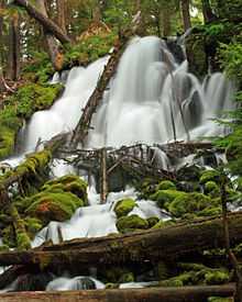
Clearwater River (Oregon)
From Wikipedia, the free encyclopedia
The Clearwater River is a river in Douglas County of the U.S. state of Oregon.[1] It is a roughly 15-mile (24 km) long tributary of the North Umpqua River, located about 50 miles (80 km) east of Roseburg in the Cascade Range.

Clearwater Falls
| coordinate | USGS map |
|---|---|
| 43°15′46″N 122°25′07″W / 43.2629°N 122.418653°WCoordinates: 43°15′46″N 122°25′07″W / 43.2629°N 122.418653°W | Toketee Falls |
| 43°14′58″N 122°23′37″W / 43.249567°N 122.393652°W | Fish Creek Desert |
| 43°14′30″N 122°22′32″W / 43.241789°N 122.375596°W | Garwood Butte |
| 43°14′59″N 122°13′37″W / 43.249847°N 122.22698°W | Lemolo Lake |
| 43°11′23″N 122°12′15″W / 43.189848°N 122.204200°W | Diamond Lake |
See also
References
External links
- Clearwater Falls: Northwest Waterfall Survey
This article is issued from Wikipedia. The text is available under the Creative Commons Attribution/Share Alike; additional terms may apply for the media files.