Clearwater Lakes
| Clearwater Lakes Lac à l'Eau Claire | |
|---|---|
 Clearwater Lakes as seen from a Space Shuttle (North is top right) | |
| Location | Baie-d'Hudson, Kativik, Quebec |
| Coordinates | 56°08′N 74°18′W / 56.133°N 74.300°WCoordinates: 56°08′N 74°18′W / 56.133°N 74.300°W |
| Type | impact crater lake |
| Primary outflows | Clearwater River |
| Basin countries | Canada |
| Surface area | 1,383 km2 (534 sq mi) [1] |
| Max. depth | 178 m (584 ft) [2] |
| Surface elevation | 241 m (791 ft) [1] |

The Lac à l'Eau Claire (the official name, in French), also called the Clearwater Lakes in English, Wiyasakami in Cree and Allait Qasigialingat by the Inuit,[3] are a pair of (annular) circular lakes on the Canadian Shield in Quebec, Canada, near Hudson Bay.
The lakes are actually a single body of water with a sprinkling of islands forming a "dotted line" between the eastern and western parts. The name is due to the clear water it holds. There are actually 25 lakes with that name in the province (26 if the Petit lac à l'Eau Claire — the Small Clearwater Lake — is included). These are the largest and northernmost, and the second largest natural lake in Quebec after Lake Mistassini.[2]
In 1896, the explorer and geologist Albert Peter Low, a member of the Geological Survey of Canada, provided the probable origin of the lakes' descriptive name by highlighting the extraordinary clarity and depth of their icy waters.[3]
Impact craters
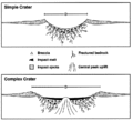
The lakes fill circular depressions that are interpreted as paired impact craters (astroblemes).[4] The eastern and western craters are 26 km (16 mi) and 36 km (22 mi) in diameter, respectively.[5][6] Both craters have the same age, 290 ± 20 million years (Permian), and it is believed that they formed simultaneously. The impactors may have been gravitationally bound as a binary asteroid, a suggestion first made by Thomas Wm. Hamilton in a 1978 letter to Sky & Telescope magazine in support of the then-controversial theory that asteroids may possess moons.[citation needed]
Micro climate
Because of its size, Lac à l'Eau Claire can affect the local climate, as attested to by the distribution of plant species. Although the lake's shorelines are populated mainly by boreal species, the flora of the central islands in the western basin of the lake is characteristically arctic, making the islands an arctic enclave.[2]
National park
A vast area surrounding the lakes, Richmond Gulf (Lac Guillaume-Delisle), and Iberville Lake (Lac D'Iberville) are part of the 15,549 km2 (6,004 sq mi) Tursujuq National Park, Quebec's largest national park, opened in 2012.[2]
References
- ↑ 1.0 1.1 Statistics Canada > summary tables > Principal lakes, elevation and area, by provinces and territories
- ↑ 2.0 2.1 2.2 2.3 Ministère du Développement durable, de l'Environnement et des Parcs, Provisional Master Plan Parc national des Lacs-Guillaume-Delisle-et-à-l'Eau-Claire, Quebec, 2008, ISBN 978-2-550-52710-7 (Online version)
- ↑ 3.0 3.1 "Lac à l'Eau Claire" (in French). Commission de Toponymie Québec. Retrieved 2009-01-30.
- ↑ Robertson, P.B. & Grieve, R.A.F. 1975 Impact structures in Canada: Their recognition and characteristics. Journal of the Royal Astronomical Society of Canada, v. 69, pp. 1-21.
- ↑ "Clearwater West". Earth Impact Database. University of New Brunswick. Retrieved 2008-12-30.
- ↑ "Clearwater East". Earth Impact Database. University of New Brunswick. Retrieved 2008-12-30.
External links
| Wikimedia Commons has media related to Clearwater Lakes. |
- Aerial Exploration of the Clearwater West Structure
- Aerial Exploration of the Clearwater East Structure

