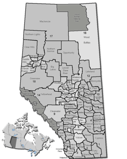
Clearwater County, Alberta
| Clearwater County | |
|---|---|
| Municipal district | |
 | |
 | |
| Coordinates: 52°22′31″N 114°55′18″W / 52.37528°N 114.92167°WCoordinates: 52°22′31″N 114°55′18″W / 52.37528°N 114.92167°W | |
| Country |
|
| Province |
|
| Region | Central Alberta |
| Census division | No. 9 |
| Established | 1985 |
| Incorporated | 2000 |
| Government[1] | |
| • Reeve | Pat Alexander |
| • Governing body |
Clearwater County Council
|
| • CAO | Ron Leaf |
| • Office location | Rocky Mountain House |
| Area (2011)[2] | |
| • Total | 18,691.78 km2 (7,216.94 sq mi) |
| Population (2011)[2] | |
| • Total | 12,278 |
| • Density | 0.7/km2 (2/sq mi) |
| • Dwellings | 4,891 |
| Time zone | MST (UTC-7) |
| Website | Official website |
Clearwater County is a municipal district in west central Alberta, Canada in Division No. 9. Its northwest boundary is the Brazeau River. The municipal office is located in the Town of Rocky Mountain House. The county has a land area of 18,691.65 km² (7,216.89 sq mi) and comprises close to 99 percent of Census Division No. 9's land area of 18,921.38 km² (7,305.59 sq mi). Although the territory excluded is rather small in geographical area, it comprises the major population centre of Rocky Mountain House, which has one-third of Division No. 9's population, in addition to the communities of Caroline, Burnstick Lake and three Indian reserves. The county's 2006 census population was 11,826 inhabitants.
 Bighorn River Valley and Crescent Falls |
The economy of the county is based on agriculture, oil and gas and forestry, with tourism increasing in importance in recent years.[3]
On July 1, 2000, the name was changed from "Municipal District of Clearwater No. 99" to "Clearwater County".[4]
Demographics
In the 2011 Census, Clearwater County had a population of 12,278 living in 4,698 of its 5,358 total dwellings, a 3.8% change from its 2006 population of 11,826. With a land area of 18,691.78 km2 (7,216.94 sq mi), it had a population density of 0.7/km2 (1.7/sq mi) in 2011.[2]
According to the Canada 2006 Census:[5]
- Population: 11,826
- % Change (2001-2006): 2.79
- Dwellings: 4,891
- Area (km²): 18,691.65
- Density (persons per km²): 0.633
Attractions
- Rocky Mountain House Historic Site in Rocky Mountain House
- Historic minesite in Nordegg
- Hiking in the Bighorn Wildland
- Camping at Burnstick Lake campsite
- Canoeing on lakes; Rafting and kayaking on Clearwater River and North Saskatchewan River
- Cross-country skiing, snowmobile trail in the Chambers Creek area
- Fishing (cutthroat, rainbow, brook and lake trout, whitefish) and hunting
Communities and localities
The following communities are located within Clearwater County:[6]
|
The following localities are located within Clearwater County:[7]
- Localities
|
|
- Other places
Phoenix, a former coal mining community between Nordegg and Rocky Mountain House,[8] is also located within Clearwater County.
See also
References
- ↑ "Municipal Officials Search". Alberta Municipal Affairs. January 24, 2014. Retrieved January 26, 2014.
- ↑ 2.0 2.1 2.2 "Population and dwelling counts, for Canada, provinces and territories, and census subdivisions (municipalities), 2011 and 2006 censuses (Alberta)". Statistics Canada. 2012-02-08. Retrieved 2012-02-08.
- ↑ Clearwater County (February 2007). "Major Industry". Retrieved 2007-03-05.
- ↑ Alberta Municipal Affairs. "Clearwater County Municipal Profile". Retrieved 2006-11-12.
- ↑ Clearwater County Community Profile - Statistics Canada.
- ↑ "Specialized and Rural Municipalities and Their Communities". Alberta Municipal Affairs. 2012-03-01. Retrieved 2012-08-11.
- ↑ "Standard Geographical Classification (SGC) 2006, Economic Regions: 4809002 - Clearwater County, geographical codes and localities, 2006". Statistics Canada. 2010-03-05. Retrieved 2012-08-11.
- ↑ "Google Books search result for "Phoenix, Alberta"". Retrieved April 8, 2010.
External links
| ||||||||||||||||||||||||||||
