Cléron
From Wikipedia, the free encyclopedia
| Cléron | ||
|---|---|---|
 | ||
| ||
 Cléron | ||
|
Location within Franche-Comté region  Cléron | ||
| Coordinates: 47°05′16″N 6°03′43″E / 47.0878°N 6.0619°ECoordinates: 47°05′16″N 6°03′43″E / 47.0878°N 6.0619°E | ||
| Country | France | |
| Region | Franche-Comté | |
| Department | Doubs | |
| Arrondissement | Besançon | |
| Canton | Amancey | |
| Intercommunality | Canton of Amancey-Loue-Lison | |
| Government | ||
| • Mayor (2008–2014) | Chantal Guet-Guillaume | |
| Area | ||
| • Land1 | 14.56 km2 (5.62 sq mi) | |
| Population (2008) | ||
| • Population2 | 307 | |
| • Population2 Density | 21/km2 (55/sq mi) | |
| INSEE/Postal code | 25155 / 25330 | |
| Elevation | 295–563 m (968–1,847 ft) | |
|
1 French Land Register data, which excludes lakes, ponds, glaciers > 1 km² (0.386 sq mi or 247 acres) and river estuaries. 2 Population without double counting: residents of multiple communes (e.g., students and military personnel) only counted once. | ||

Cléron is a commune in the Doubs department in the Franche-Comté region in eastern France.
Population
| Historical population | ||
|---|---|---|
| Year | Pop. | ±% |
| 1962 | 167 | — |
| 1968 | 188 | +12.6% |
| 1975 | 182 | −3.2% |
| 1982 | 235 | +29.1% |
| 1990 | 266 | +13.2% |
| 1999 | 294 | +10.5% |
| 2008 | 307 | +4.4% |
Sights
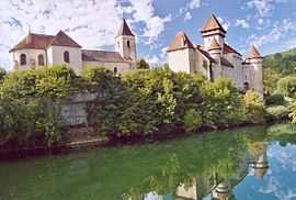
- The Château de Cléron is a 14th-century castle, remodelled over the years. Its privately owned and not open to visitors, though the gardens are opened during the summer. It has been listed since 1988 as a historic site by the French Ministry of Culture.[1]
See also
References
| Wikimedia Commons has media related to Cléron. |
This article is issued from Wikipedia. The text is available under the Creative Commons Attribution/Share Alike; additional terms may apply for the media files.