Cisek
| Cisek | |
|---|---|
| Village | |
 Cisek | |
| Coordinates: 50°17′N 18°12′E / 50.283°N 18.200°E | |
| Country |
|
| Voivodeship | Opole |
| County | Kędzierzyn-Koźle |
| Gmina | Cisek |
| Population | 1,485 |
| Website | http://www.cisek.gmina.pl/ |
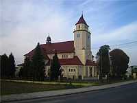
Cisek [ˈt͡ɕisɛk] (German: Czissek) is an agricultural village in Kędzierzyn-Koźle County, Opole Voivodeship, in south-western Poland. It is the seat of the gmina (administrative district) called Gmina Cisek.[1] It lies approximately 8 kilometres (5 mi) south of Kędzierzyn-Koźle and 47 km (29 mi) south-east of the regional capital Opole. The village has a population of 1,485.
History
Before 1945, the area was part of Germany (see Territorial changes of Poland after World War II), however the first mention of the village was in 1241. In 1532, it was named as Czisky and Cisek. In 1830, the village had 564 residents and 138 houses. By 1845, it had grown to 760 inhabitants and 129 houses. A Roman Catholic school, founded in 1818, employed one teacher and one assistant teacher. In 1865, the total area of the village was 2,037 acres. According to the census of 1910, the village was inhabited by 1,206 Poles. In the census of 1925, the Polish language was listed as the native tongue of 901 villagers, German was only listed by 64 people, and 343 people were recorded as bilingual.

From 1925 - 1933, a Polish language public school functioned in the village. There was also a branch of the Polish-Catholic School Society. In 1937, the village caused an uproar in the Polish community of Germany due to the county authorities in Koźle denial of a license to suspend the village's newly acquired church tower bells. The bells had been funded by local Polish parishioners. The German authorities had stated that the tower was too weak to hang the heavy bells. Finally, the authorities agreed to suspend the bells after removing the Polish inscription from them which read, "Hail Mary, pray for us." The Union of Poles in Germany also registered two more cases of destruction of Polish inscriptions, which were placed on the roadside crosses, at this time.
In 1997 the village was heavily effected by the Millennium Flood. The flood destroyed nearly all the season's crops and many roads. The village is partnered with both Breitungen and Körperich in Germany.

General statistics
- Population: 1,485
- Population density: 280 people/km²
- Area: 5.3 km2
- Forests and forest land: 450 acres[2]
Population trends
| Year | Population |
|---|---|
| 1880 | 1,070 people[3] |
| 1933 | 1,394 people[3] |
| 1939 | 1,433 people[3] |
| 1945 | 1,320 people[3] |
| 1948 | 1,233 people[3] |
| 1960 | 1,367 people[3] |
| 2005 | 1,485 people |
Gallery
-

Wayside Chapel is a village landmark.
-

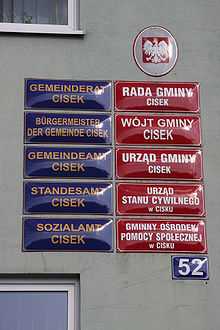
Bilingual signs at the municipal office
References
Further reading
| Wikimedia Commons has media related to Cisek. |
Popiołka, Stefan, Ziemia Kozielska. Opolskie Zakłady Graficzne. Opole, 1963.
| ||||||||
Coordinates: 50°17′N 18°12′E / 50.283°N 18.200°E