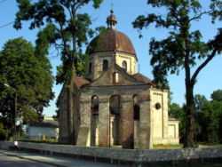
Cieszanów
From Wikipedia, the free encyclopedia
| Cieszanów | ||
|---|---|---|
 | ||
| ||
 Cieszanów | ||
| Coordinates: 50°16′N 23°8′E / 50.267°N 23.133°E | ||
| Country |
| |
| Voivodeship |
| |
| County |
| |
| Gmina | Cieszanów | |
| Government | ||
| • Mayor | Zdzisław Zadworny | |
| Area | ||
| • Total | 15.09 km2 (5.83 sq mi) | |
| Population (2006) | ||
| • Total | 1,899 | |
| • Density | 130/km2 (330/sq mi) | |
| Time zone | CET (UTC+1) | |
| • Summer (DST) | CEST (UTC+2) | |
| Postal code | 37-611 | |
| Car plates | RLU | |
| Website | http://www.cieszanow.org | |
Cieszanów [t͡ɕeˈʂanuf] (Ukrainian: Тішанів or Цішанів or Чесанів, Tishaniv or Tsishaniv or Chesaniv; Yiddish: ציעשינאוו-Tseshenov) is a town in Lubaczów County, Subcarpathian Voivodeship, Poland. It has a population of 1,916 (02.06.2009).[1]
In 1921 there were 929 Jews in Cieszanów.[2]
History
From the first partition of Poland in 1772 until 1918, the town was part of the Austrian monarchy (Austria side after the compromise of 1867), head of the district with the same name, one of the 78 Bezirkshauptmannschaften in Austrian Galicia province (Crown land).[3] The fate of this province was then disputed between Poland and Ukraine.
References
- ↑ "Population. Size and structure by territorial division". © 1995-2009 Central Statistical Office 00-925 Warsaw, Al. Niepodległości 208. 2009-06-02. Retrieved 2009-06-22.
- ↑ JewishGen
- ↑ Die postalischen Abstempelungen auf den österreichischen Postwertzeichen-Ausgaben 1867, 1883 und 1890, Wilhelm KLEIN, 1967
Coordinates: 50°16′N 23°08′E / 50.267°N 23.133°E
| ||||||||||
This article is issued from Wikipedia. The text is available under the Creative Commons Attribution/Share Alike; additional terms may apply for the media files.
