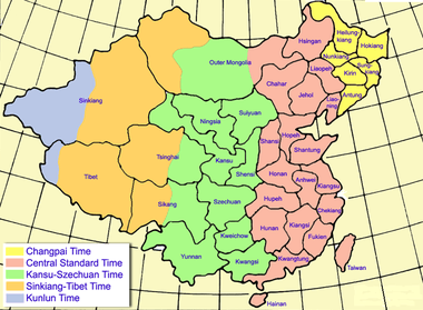
Historical time zones of China

In 1912, the Central Observatory of the Republic of China in Peking (now romanised as Beijing) divided the country into five time zones, namely Kunlun Time Zone (GMT+5.5), Sinkiang-Tibet Time Zone (GMT+6), Kansu-Szechuan Time Zone (GMT+7), Chungyuan Standard Time Zone (GMT+8), and Changpai Time Zone (GMT+8.5). These time zones were ratified in 1939 in the standard time conference of the Ministry of Interior of the Executive Yuan.
These time zones were no longer in effective use after 1949, in the Chinese Civil War when the People's Republic of China was established on mainland China. The People's Republic of China uses a single time zone (GMT+8) for the whole country, although GMT+6 is also used unofficially in Xinjiang and Tibet. The Republic of China on Taiwan continued to use Chungyuan Standard Time Zone as the official name of the time zone in the remaining territories under its effective jurisdiction, however in recent decades this use has been largely deprecated.
Kunlun
The Kunlun Time Zone (Chinese: 崑崙時區; pinyin: Kūnlún Shíqū) was assigned to the area around the Kunlun mountain ranges in the far west of China, based on the time on the longitude 82°30′E. Administrative divisions within this time zone were:
- western part of the Sinkiang Province (now Xinjiang Autonomous Region of the People's Republic of China (PRC))
- western part the Tibet Region (now part of the Tibet Autonomous Region of the PRC)
- Pamir highlands, claimed by China but effectively a part of Soviet Union and now a part of Tajikistan
Sinkiang-Tibet
The Sinkiang-Tibet Time Zone (Chinese: 新藏時區; pinyin: Xīn-Zàng Shíqū) was named after the administrative divisions of Sinkiang and Tibet, which had the majority of their land lying in this time zone. The time zone also covered the western halves of their neighbouring administrative divisions. The time in this time zone was based on that on the longitude 90°E. Administrative divisions within this time zone included:
- eastern part of the Sinkiang Province (now Xinjiang Autonomous Region of the PRC)
- eastern part of the Tibet Region (now part of the Tibet Autonomous Region of the PRC)
- western part of Tsinghai Province (now transliterated as Qinghai Province by the PRC)
- western part of Sikang Province (now part of the Tibet Autonomous Region and Sichuan Province of the PRC)
- the western part of the Mongolia Region (now the independent state of Mongolia).
- the two Soviet (now Russian) republics of Tuva and Gorno-Altay
Kansu-Szechuan
The Kansu-Szechuan Time Zone (Chinese: 隴蜀時區; pinyin: Lǒng-Shǔ Shíqū) covered the mid-western part of China, based on the longitude 105°E. Administrative divisions within this time zone were:
- Kansu Province (now transliterated as Gansu Province by the PRC)
- Szechuan Province (now part of the Sichuan Province of the PRC)
- Ningsia Province (now the Ningxia Autonomous Region of the PRC)
- Suiyuan Province (now part of the Inner Mongolia Autonomous Region of the PRC)
- Shensi Province (now transliterated as Shaanxi Province by the PRC)
- Kweichow Province (now transliterated as Guizhou Province by the PRC)
- Kwangsi Province (now transliterated as Guangxi Province by the PRC)
- Yunnan Province
- eastern half of the Tsinghai Province
- eastern half of the Sikang Province
- central part of the Mongolia Region
Chungyuan
The Chungyuan Standard Time Zone (Chinese: 中原標準時區; pinyin: Zhōngyuán Biāozhǔn Shíqū), or Central Standard Time Zone, covered the densely populated area of the ROC, including the then capital Nanking. As political and social environments have been changing, the term "Chungyuan Standard Time" is now rarely in use in Taiwan, while National Standard Time have become the alternative. The time in this time zone was, however, based on the longitude 120°E. Administrative divisions in this time zone were:
- Hsingan Province (now part of the Inner Mongolia Autonomous Region of the PRC)
- Liaopeh Province (now part of the Inner Mongolia Autonomous Region of the PRC)
- Chahar Province (now part of the Inner Mongolia Autonomous Region)
- Hopeh Province (now transliterated as Hebei Province by the PRC)
- Jehol Province (now part of the Hebei Province and the Inner Mongolia Autonomous Region of the PRC)
- Liaoning Province
- Shantung Province (now transliterated as Shandong Province by the PRC)
- Shansi Province (now transliterated as Shanxi Province by the PRC)
- Anhwei Province (now transliterated as Anhui Province by the PRC)
- Kiangsu Province (now transliterated as Jiangsu Province by the PRC)
- Chekiang Province (now transliterated as Zhejiang Province by the PRC)
- Hupeh Province (now transliterated as Hubei Province by the PRC)
- Hunan Province
- Kiangsi Province (now transliterated as Jiangxi Province by the PRC)
- Fukien Province (now transliterated as Fujian Province by the PRC)
- Kwangtung Province (now transliterated as Guangdong Province by the PRC)
- Hainan Special Administrative District (now Hainan Province of the PRC)
- Taiwan Province (then under Japanese rule)
- eastern part of the Mongolia Region
Changpai
The Changpai Time Zone (Chinese: 長白時區; pinyin: Chángbái Shíqū) covered Northeast China. Named after the Changpai mountain range on the border between China and Korea, it was based on that on the longitude 127°30′E. Administrative divisions within this time zone included:
- Heilungkiang Province (now part of the Heilongjiang Province of the PRC)
- Hokiang Province (now part of the Heilongjiang Province of the PRC)
- Kirin Province (now part of the Jilin Province of the PRC)
- Nunkiang Province (now part of the Jilin Province of the PRC)
- Sungkiang Province (now part of the Jilin Province the PRC)
- Antung Province (now part of the Liaoning Province of the PRC)
See also
- Time in China
- Time zones